Garmin FAQ
Garmin GPS 45/40/38 Frequently Asked Questions
==============================================
V 1.07 April 23, 1996
Compiled by Lane A. Holdcroft
Garmin 45/40/38 FAQ Copyright 1995, 1996 by Lane A. Holdcroft.
Original contributors retain their copyright for all of their contributions.
You may copy this in its entirety, but not for monetary benefit.
If a portion of this document is quoted, please give the original author
credit.
After many, many delays, here is the new version of the Garmin FAQ which now
includes the new GPS 38 and the GPS 120. I am still reviewing the many
suggestions and postings that I have received for inclusion in future
versions.
|
This document is not in any way endorsed by Garmin International.
I am not affiliated with Garmin or any of their retailers.
This FAQ is targeted primarily at the GPS 45, GPS 40, and GPS 38.
The GPS 90 is very similar to the GPS 45 but has different software and much
more non-volatile memory for its aero navigation database.
|
The GPS 38 (released late Feb 1996), is very similar to the GPS 40. However,
it has improved software, no external antenna connector, no beeper, no video
tape, and a lower price. See the new section "GPS 38 reports".
|
The GPS 120 (released late 1995) has almost identical software to the GPS 45
but a mobile mount, external antenna and a much larger display .
|
There are many other Garmin instruments that have many internal similarities
(and some software compatibility) to the GPS 45/40/38 such as the GPS 50, 65,
and 75. There is also a table at the end of the FAQ with most Garmin
products.
|
TABLE OF CONTENTS:
==================
0.00
ABOUT THIS FAQ:
-General FAQ info?
-Attribution?
-FAQ revision history?
-Future features?
-Suggestions for improvement?
1.00
GENERAL FEATURES:
-What are some key features of the Garmin GPS 45/40/38?
-What are the disadvantages of the GPS 45/40/38?
-What are the differences between the GPS 45 and GPS 40?
-What is the accuracy of the GPS 45/40/38/90?
-What is the Garmin GBR 21 Differential Beacon Receiver?
-Are there any other differential receivers available? |
-How can I improve the accuracy of a GPS unit w/ averaging? |
-How Accurate is the clock on the GPS 45/40/38/90? |
-What is the MOB function? |
-What is a waypoint? |
2.00
SPECIFICATIONS/REPORTS:
-GPS 45/40 specifications?
-GPS 45/40 reports/description?
-GPS 90 press release/specs?
-GPS 30/31 description?
-GPS 38 reports? |
-GPS 120 description? |
3.00
FIRMWARE (GPS 45/40/38 INTERNAL SOFTWARE):
-90 knot speed limit?
-GPS 45/40 firmware versions?
-What are the undocumented modes?
-Why is internal temperature available?
4.00
BATTERY/POWER:
-How is power selected between the internal batteries and the external supply?
-What voltages do the fuel gauge correspond to?
-Current consumption of a GPS 45 at different external supply input voltages?
-How does BatterySave mode work?
-Rechargable batteries?
-Other battery/external power options?
-How long is memory conserved without batteries?
-Does the serial I/O consume much more power when it is enabled?
5.00
SERIAL/POWER INTERFACE:
-External serial/power connector alternatives?
-How do I interface the GPS 45/40/38 to an IBM-PC compatible computer?
-How do I interface the GPS 45/40/38 to a Macintosh?
6.00
APPLICATION SOFTWARE:
-What Macintosh software is available for Garmin GPS units?
-What MS-DOS/Win software is available specifically for Garmin GPS units?
-What MS-DOS/Win software is available that communicates using NMEA 183 format?
-Other MS-DOS/Win software? |
-GPS ftp/www sites?
-CD-ROM maps with lat/lon?
7.00
ANTENNAS:
-What is the GPS 40/38 internal antenna?
-How is the GPS 45/90 antenna internally constructed?
-How well does the internal antenna work inside a car?
-What are the remote antenna options?
-GPS 45/90 antenna extension cables?
-Can I make my own external antenna?
-What is the loss for different coaxial cables?
-What is the GPS 40 antenna connector?
8.00
MISCELLANEOUS:
-GPS mounting options?
-Waterproofness?
-Cases?
-Garmin 45/40/38 wish list?
-Can I use my GPS unit in a plane?
-Performance in trees?
-Internal electrical hardware?
-Why is the firmware not in a socket?
-Can I receive GPS signals through my house?
-For how long will a particular track interval interval collect data?
9.00
GARMIN PRODUCTS:
-Garmin GPS models?
-Garmin accessories?
-Where can I purchase a unit?
----------------------------------------------------------------------
QUESTIONS AND ANSWERS:
======================
0.00
ABOUT THIS FAQ:
---------------
-General FAQ info?
The Usenet newsgroup "sci.geo.satellite-nav" has a high proportion of
questions dealing with the very popular Garmin GPS 45, GPS 40, and GPS 38.
I hope this will answer most of them.
Because of the large number of questions that are still posted to the
newsgroup that have been answered in this FAQ, I usually post this every
couple of weeks to the newsgroup "sci.geo.satellite-nav".
The newsgroup was originally intended to be oriented more towards
professionals in the GPS business rather than recreational users that are
more inclined to use the GPS 45/40/38 because of their low prices. However,
there is a lot of discussion about Garmin units.
|
This FAQ is based on my experience with my GPS 45 and others' postings
to the GPS newsgroup since the GPS 45 was first introduced about March 1994.
I have a particular interest in the electrical aspects of these units.
The latest version of this FAQ and some links to other sites can be found
at my www or ftp sites (or Peter's site in the next section):
http://www.eskimo.com/~klah/index.html (preferred)
or ftp to "ftp.eskimo.com", cd to "/u/k/klah"
or ftp://ftp.eskimo.com/u/k/klah/index.html
For more general information not specific to the Garmin units, read the new
general GPS FAQ maintained by Peter Bennett. It is available on his
excellent ftp site. I also send the latest version of this Garmin 45/40/38
FAQ there.
ftp://sundae.triumf.ca/pub/peter/index.html
or ftp to "sundae.triumf.ca", cd to "/pub/peter"
A fair amount of the information posted about the Garmin units in the GPS
newsgroup is wrong. I have spent a lot of time trying to make this document
error free, but there is no guarantee to the accuracy of this information!
Minor errors have been found in the past.
When the term "GPS receiver" or "GPS unit" is used in this FAQ, this is meant
to refer to a handheld unit that uses the Global Positioning System.
Technically, the "receiver" is the radio portion of the handheld device only
and the term "GPS" refers to the complete navigation system and not the unit
itself.
|
-Attribution?
Thanks to the many people who have contributed to this document! I tried to
give credit to the original author at the end of each contribution. If an
answer does not have an attribution, I usually answered it based on my
recollection of the consensus of previous postings and/or my personal
experience or the contributor did not want credit. If I felt clarification
within another person's quoted material would be beneficial, my comments
are contained within the brackets "[" and "]".
-FAQ revision history?
Ver Date Major changes
--- ---- -------------
1.00 Aug 4, 1995 Initial release
1.01 Aug 7, 1995 Minor corrections
1.02 Aug 20, 1995 Added detailed speed limit info
Added GPS 90 info
Added more detailed list of specs
Added Garmin accessory list
1.03 Aug 22, 1995 Minor corrections
1.04 Aug 29, 1995 Added Garmin 45/40 wish list
Added section head numbers
Added GPS 45 external current consumption
Added FAQ revision history
1.05 Sep 18, 1995 Added info about "Diag mode"
Added info about Accuracy
Added info about Garmin differential receivers
Added "|" indicating major changes in line or paragraph
Reordered several sections
Split out application software into its own heading
Many minor corrections
1.06 Oct 10, 1995 Added section on coax cable losses
Added section on CD-ROM map programs
Added section on houses blocking signals
Added GPS 40 mode from a GPS 45
Added GPS 30 info
Expanded ftp/www sites considerably
Expanded Garmin DGPS info
Split application software to Garmin & NMEA 183
Split out intro into a separate section
Minor corrections
1.07 April 23, 1996 Added sections on GPS 38 & 120
Added info on BatterySave mode
Added info on memory backup
Added Eagle Accunav info (8.00, Performance in trees)
Added other PC software section
Added more info on Macintosh software
Added improving the accuracy section
Expanded Garmin GPS models section
Reduced the Garmin software price
Updated Garmin's address and phone numbers
Updated several E-mail addresses
PLEASE DESTROY ALL PREVIOUS VERSIONS, ESPECIALLY BEFORE VERSION V1.06
because they had at least several errors.
The "|" character is used to mark paragraphs or a line for significant
changes in content from the previous version of the FAQ.
-Future features?
Simple explanation of GPS, time, S/A, and differential receivers and how
accuracy is affected.
-Suggestions for improvement?
You can help improve this document by sending E-mail to me about errors or
suggestions for improvement. It would be very useful if you could give your
sources of information. Also, please include the version of the FAQ and the
firmware version of your GPS 45/40/38. There is often conflicting information
and your detailed references are valuable for resolving those discrepancies.
I receive lots of feedback but it takes time to process and verify
all of the information. Because of the large volume of E-mail I receive,
I can not always acknowledge all mail. I also can not answer individual
questions not pertaining to the FAQ. However, I do read all feedback and
do take note of it. I read the newsgroup very regularly but occasionally
I do miss something Garmin related.
Please send CONSTRUCTIVE suggestions to Lane A. Holdcroft
(klah@eskimo.com)
1.00
GENERAL FEATURES:
-----------------
-What are some key features of the Garmin GPS 45/40/38?
Garmin GPS 45/40/38 specific:
Relatively inexpensive (list < $500 US, discounted < $300 US).
Very feature rich.
Long (10 hour) battery life w/ 4 AA alkaline batteries.
Very compact size.
Serial port allowing transfer of data to/from a PC/Mac.
Neat 768 point track log feature which can be graphically displayed.
Ability to download the above track log data to a PC/Mac.
Easy to use due to a simple menu system.
Water resistant.
64 x 100 pixel graphical display.
Over 100 mapping datums used around the world.
-What are the disadvantages of the GPS 45/40/38?
1) There is a firmware speed limit of 90 knots / 104 MPH. See "90 knot speed
limit" question elsewhere in the FAQ for more details. The GPS 90 does
NOT have this limitation.
|
2) The list prices on some options are more expensive than some competitors.
For example, a replacement 45 antenna is $100 list and external power
and/or data cables are between about $25 and $50. However, some dealers
offer substantial discounts.
3) Because of the GPS 45/40/38/90's compact size, there is not sufficient space
for number buttons. It has a 4 position rocking button to enter numbers
and names. This is not as fast as using a keypad. The Garmin GPS 75 is
somewhat larger and does have a full numeric keypad.
4) The display size is very small. This is a very compact GPS unit.
The character size is also very small on the GPS 45/40/90. However the
the new GPS 38 uses a wider font to be more readable. If you have good
corrected vision, it should not be a problem up close. If not, then the
GPS 45/40 may not be a good choice for you.
|
5) The GPS 45/40/38 (like all other sequential receiver GPS units) is not
able to track as well under heavy tree cover as parallel receiver designs.
See "Performance in trees" section for details.
-What are the differences between the GPS 45 and GPS 40?
1) The GPS 45 has an external quad-helix swivel antenna (about 3/4" x 3/4"
x 3") whereas the 40/38 has compact "patch" antenna built into the main
case. A GPS 40/38 looks like a GPS 45 without the swivel antenna.
The GPS 45 uses a standard BNC connector for the antenna, whereas the GPS
40 has a "MCX" type connector for the optional external antenna.
The GPS 45's external antenna hangs out the side of the instrument and
could be broken if it were snagged or handled roughly ($100 replacement
cost!). This is not a problem with the GPS 40/38.
The GPS 45's BNC connector is preferable if you want to add an extension
cable since BNC extensions are available from many more sources. This is
an advantage because you can avoid the cost of an additional antenna if
you want to temporarily mount it remotely from the GPS unit.
The GPS 45's BNC connectors are more subject to corrosion from salt water
and the 45's antenna could leak if it was not well sealed.
|
The GPS 45 can be held at different viewing angles as long as the
antenna is swivelled vertically whereas the GPS 40/38 must be held at a
specific angle for optimum reception.
|
There is a lot of debate about the exact differences in antenna
sensitivity, however the GPS 45 is apparently slightly more sensitive for
satellites that are directly overhead.
2) The GPS 45 takes a much wider range of input voltages (up to 40 Volts).
This is because the 45 has an internal switching power supply whereas
the GPS 40/38 do not and the GPS 40/38 are only rated for 5 to 8 Volts for
external power. Connecting the GPS 40/38 directly to a higher voltage
supply would be potentially damaging.
Therefore, the mobile power cigarette adapter is $20 more expensive for
the GPS 40/38 (because it must include a regulator). Also, the GPS 40/38
has an additional center pin in the center of the power/data connector to
prevent the use of the GPS 45 cigarette lighter cord which would probably
damage the GPS 40/38 due to overvoltage.
|
3) The GPS 40 includes a video tape on its operation.
4) The GPS 40/38 has a dark gray case, whereas the GPS 45 has a white front
case and a black rear case.
|
5) The GPS 40 is about $20-$40 US cheaper.
|
-What is the accuracy of the GPS 45/40/38/90?
Note that the error tolerance displayed on the GPS does NOT include errors
due to SA. |
Note that all position accuracy specs for the GPS are based on 95% DDRMS
and assume the best satellite coverage possible.
Horizontal accuracy:
100 meters Official accuracy (Selective Availability ON)
~45 meters Actual accuracy (Selective Availability ON) |
15-20 meters Theoretical accuracy (Selective Availability OFF) |
8-10 meters Differential accuracy (regardless of Selective Availability)
Vertical accuracy (altitude):
Approximately 1.5 times worse than horizontal accuracy depending on the
geometry of acquired satellites. In fact, you can get better vertical
accuracy with an altimeter (but it must be regularly adjusted to compensate
for changes in barometric pressure). The errors in altitude due to SA are
especially obvious when you are on the ocean!
|
-What is the Garmin GBR 21 Differential Beacon Receiver?
The US and Canadian governments are setting up Differential GPS (DGPS)
stations to transmit correction signals. They are usually broadcast on
existing marine beacon frequencies around 300 KHz. They are already
operational in many areas along the coasts.
In addition to compensating for errors in the postion, these correction
signals also undo the deliberate degradation of the accuracy by the U.S.
Department of Defense.
Look at the US Coast Guard's web site (under "ftp/www sites" in this FAQ)
for locations and status of their differential stations.
|
When connected to your Garmin GPS, the GBR 21 will increase its accuracy to
under 10 meters when within receiving range of Differential Beacon stations
on the coasts. This also makes your speed indications accurate to about 1/10
knot, which is great for sailboat racers. Works with DGPS-ready GPS 40, 45,
50, 65, 75, and GPSMAP 210/220 models. Coupler measures 1.6"D x 4.8"H and
requires a 4' whip antenna. 30' RG-58 coax included. Receiver box measures
5.2"x3.6"x1.5". Draws 130 mA. One year parts and labor includes water damage.
List $799
[West Marine Catalog]
-Are there any other differential receivers available? |
Some other manufacturers' differential units that pick up the Coast Guard
broadcasts can be used with a Garmin GPS unit but they can not automatically
tune the frequency of the differential receiver as Garmin's can. I don't
know how much of an advantage this is. There are probably some other
differences also. I would appreciate a detailed review by an user of this
option.
There are services that transmit correction signals on FM broadcast band
subcarriers but you must buy their differential receivers and pay a monthly
charge.
There are also services that transmit correction signals via satellite and
again you must buy their differential receiver and pay a monthly charge.
-How can I improve the accuracy of a GPS unit w/ averaging? |
Because the Garmin 45/40/38 units do not save the individual satellites used
and their timing information for each fix, you can not postprocess the data.
Another problem is that the displayed information is averaged rather than
being real-time.
However, you can average your position. Although the official accuracy of
the GPS system for non-military users is 100 meters 95% of the time, in fact
when you look at the data plots (such as available from MIT elsewhere in the
FAQ), you can see that the accuracy is more like 45 meters.
This can be improved much further by averaging. You can turn on the track log
feature, and leave the GPS on for a long time, and then look at the map screen
and then just visually average the postion. Of course this can be done more
precisely by downloading the data and averaging it on a computer.
It has been suggested by several people that if you want maximum accuracy,
you could take 1 reading every 15 minutes. This is believed to be the minimum
amount of time to get nearly independent readings without the affects of SA.
Of course to get a reasonable number of readings you should collect data for
many, many hours and you would need an external power supply so that you
don't wipe out your batteries before your data collection is done.
The concept of averaging is based on the assumption that the errors
(especially due to SA) are centered about zero. In fact the specification
for SA does not require zero offset, but this is usually the case. It is
felt by some in the newsgroup that that the maximum accuracy with extensive
averaging is about +/- 10 meters.
-How Accurate is the clock on the GPS 45/40/38?
|
First of all, there is a clock IC in the unit to keep the approximate time.
To get accurate time, you must be locked on several satellites.
Internally the GPS unit knows the time more accurately than 1 uS,
however the display and serial port are lower priority tasks and will not
be updated immediately. We don't know the maximum error but expect that
it should be less than several seconds. When I have crudely compared the
displayed time to the international time standards (received by shortwave
radio), the difference has usually been well under 1 second.
To get extremely accurate time, there are other GPS's that have a precise
timing output.
|
-What is the MOB function? |
The Man Over Board function is a common feature for marine GPS units. If a
person were to fall overboard, the skipper uses this function to immediately
mark the current location and the GPS goes into a "Go To" mode where it
directs the skipper back to the point where the button was pressed. It is
not trivial to find a person at sea with strong winds and large waves.
|
-What is a waypoint? |
A waypoint is a nautical term referring to a label used to mark a specific
location. For a GPS unit, a waypoint can be any location you want to mark
and label in memory for future reference.
2.00
SPECIFICATIONS/REPORTS:
-----------------------
-GPS 45/40 specifications?
Here are the specs out of the manual:
Physical
Case: Waterproof, dry nitrogen-filled
Size: 6.15"H x 2"W x 1.23"D
(15.6 x 5.1 x [3.12] cm) |
Weight: 10 ounces [0.284 kg] w/ batteries.
Temp Range: 5 to 158 degrees F [-15 to +70 degrees C]
Performance
Receiver: Differential-ready MultiTrac8
Acquisition Time: Approx 20 seconds (warm)
Approx 2 minutes (cold)
Approx 7.5 minutes (autolocate)
Update rate: 1/sec, continuous
Position Accuracy 5-10 meters (16-33 ft) with DGPS correction
15 meters (49 ft) RMS*
*subject to accuracy degradation to 100m [95% of the time]
under the DOD imposed Selective Availability Program
(note: I average 150')
Velocity Accuracy 0.1 knot RMS steady state
[w/o SA, several knots error w/ SA]
Dynamics: Performs to specs to 3g's
Power
Input: 4 AA batteries or 5-40 vDC
Usage: .75 watts
Battery life: 10 hours (normal mode)
w/alk. batt. Up to 20 hours in battery saver mode
Kai Schumann Schumann_Kai@Lilly.com
----------------------------------------------------------------------
-GPS 45/40 reports/description?
Here are 2 good reviews that were posted to the newsgroup. One is from a
45 owner, the other from a 40 owner. Keep in mind that other than the
antenna and input voltage range, both units are IDENTICAL and most comments
apply to both. I have included their reviews pretty much in full because
they do a very good job of covering the features of these units, and they
both include lots of useful information which would be beneficial to someone
who is contemplating buying a Garmin unit.
>From: gscott@netcom.com (Gavin Scott)
Date: Wed, 27 Apr 1994 04:46:39 GMT
Today I received a new Garmin GPS 45
Here are my initial impressions, along with a list of features
and specifications for the unit. I will follow up with more
comments in a week or so after I have had a real chance to play
with it for a while.
I have no connection with Garmin or West Marine. I purchased
the GPS 45 myself, for my own use. I have owned handheld GPS
receivers going back to the original Magellan Nav-1000 (which
has now been upgraded repeatedly and is a NAV5000 now). I have
some experience with other GPS units including a Garmin GPS100
owned by a friend.
The brand new (shipping for only a week or so) Garmin GPS 45
looks to be the hottest handheld around. It is a small
(literally pocket sized) 10oz package, and yet sports a large
graphic LCD display.
For a picture, look in the current West Marine catalog (you
can get one from them at 1-800-538-0775) or most other marine
equipment dealer catalogs, or call Garmin at 1-800-800-1020
and ask them to fax you a data sheet.
------- GARMIN GPS 45 ---------
PHYSICAL DESCRIPTION:
This sucker is small! It easily disappears into the front
pockets of my Levis Dockers. The spec sheet lists the
dimensions as 6.15 inches high, 2 inches wide, and 1.23
inches deep. Weight is an amazing 10 ounces (spec sheet,
4 AA batteries included), and my cheap postal scale
weighs it in at 11 ounces (with batteries and case).
At the top on the right side is a recessed BNC connector
where the tiny built in flip-up antenna is attached. The
antenna is of the same sort as the Magellan and Garmin units
have used for some time, except for the size! The GPS 45
antenna measures 3 inches long by 0.775 inches square.
The dimensions of the main unit given above do not include
antenna, which makes the top of the unit about 3 inches
wide overall.
The most striking feature of the GPS 45 (after size) is the
large LCD display which takes up the bottom half of the
front of the unit. The display has a 'portrait' orientation,
being much taller than it is wide.
Above the display is a four way rocker switch surrounded by
six other buttons. This layout allows the unit to be easily
held in either hand with the thumb operating the buttons. The
joystick like flat rubber rocker switch is used for all data
entry. Alpha-numeric data is entered by cycling through the
possible letters/numbers. To the left of the rocker 'cursor'
button are (top to bottom) GOTO, Power/Backlight, and QUIT
buttons. to the right are PAGE, MARK and ENTER. The top
1/4 of the front is blank except for a logo (picture of the
earth with no text).
The front part of the unit is white, and the back is black.
Batteries (4 AA) are inserted into the bottom, beneath a
seal opened with a quarter turn fold out doohickey. The
batteries disappear into two tubes. I don't know where they
have room for the electronics with all that space taken up
inside by the batteries!
A 4 pin (round DIN like) connector is on the back. The pins
are described in the manual as Ground, Power in (5-40 VDC!),
and DATA IN and DATA OUT. A rubber plug protects the
connector when it is not in use.
The whole unit is waterproof, and is actually filled with
dry nitrogen and the waterproofness is covered by the one year
warranty.
ACCESSORIES INCLUDED:
4 AA [alkaline] batteries (installed).
[A carrying case.] |
A reference manual (61 pages, dated February 1994).
A quick reference card (which is too big to fit in the case,
but printed on plastic waterproof paper).
Warranty registration card.
An offer to sell you a training video for $29.95
A wrist strap.
The whole mess comes in a white cardboard box with pale Garmin
logos on it that is about 11"x7"x3".
SPECIFICATIONS:
Temp range 5-158 degrees F (-15-70C).
Acquisition times: 20 seconds (warm), 2 minutes (cold), 7.5
minutes (sky search).
Update rate 1/second.
Position accuracy 5-10M (with DGPS), 15M RMS (without SA),
[100 Meter accuracy with 95% confidence (with SA on, as is the
case now)]
Dynamics: 3g's.
Power usage .75 watts.
Battery life 10 Hours normal, 20 hours battery saver mode.
NMEA INTERFACE INFORMATION:
NMEA 0180, 0182.
0183 version 1.5 (Approved sentences BWC, GLL, RMB, RMC,
XTE, VTG, WPL; Proprietary sentences PGRMM (map datum),
PGRMZ (altitude), PSLIB (DGPS beacon remote control)).
0183 version 2.0 (Approved sentences GCA, GLL, GSA, GSV,
RMB, RMC, RTE, WPL; Proprietary sentences PGRME (estimated
error), PGRMM (map datum), PGRMZ (altitude), PSLIB (DGPS
beacon remote control).
Plus Garmin's proprietary bi-directional format that allows
upload/download of waypoints and other information with
appropriate software.
DGPS corrections are accepted from any RTCM-104 v2.0 format
compatible beacon receiver, but use of Garmin's GBR 21
(discounted to $500) will allow tuning and control
from the GPS 45 itself (using the proprietary NMEA data
strings above).
OPERATIONAL DESCRIPTION, FEATURES, PRELIMINARY EXPERIENCES:
To turn it on, you press the power button down firmly.
You are greeted with an animated spinning
globe and in large letters "Welcome to the Garmin GPS 45"
and it gives the firmware revision as "2.02".
First displayed is the satellite status screen. This nifty
display shows the position in the sky for each satellite, a
bar graph of the signal strength of up to 8 stats at a time,
a large battery power gauge bar, a backlight indicator (a very
useful feature in daylight when you can't tell if the blue
EL backlight is on or not), and a status message ("Acquiring"
etc).
Pressing the PAGE key cycles through the main displays which
are as follows:
POSITION PAGE:
Shows a graphical compass display (like looking at a compass
from eye level).
Ground track and speed, Position in LAT/LON down to .001 minutes
resolution, Altitude (including an accuracy +- value!), and the
current time (Local time not GPS time) with 1 second resolution.
MAP SCREEN
This is way cool. You get a moving map display that will let
you zoom from a 0.2 mile range up to 320 miles. You can also
pan around, point to waypoints, create new waypoints by pointing
etc. There is no provision for a map database, but the nine
nearest waypoints can be displayed with their names, along with
range circles, course, ground track, and other information, all
configurable. You can have TRACK UP or NORTH UP as you like.
CROSS TRACK (CDI) SCREEN:
Shows bearing and distance to next waypoint, graphical XTE and
distance to go, current time and ETE, Track and Speed, etc.
MENU SCREEN:
>From here you get to enter waypoints and routes and do all the
setup stuff. There are about 16 screens of config data and
stuff accessible.
OTHER MISCELLANEOUS STUFF:
Let's see, it is getting late so let me try and highlight the
other unusual features. Of course all the stuff for creating
routes and waypoints is there. You get 250 Alphanumeric
waypoints (which you can add an annotation line of info to!),
20 reversible routes, Man Overboard mode (Press GOTO twice).
I have only operated it outside enough to get an initial fix
(sky search) and try out some basic stuff and the moving map.
If you lose memory (almanac) data or move >300 miles you are
forced to do a 7.5-15 minute sky search [unless you enter
the new coordinates]. Once this is done,
acquisitions are fast, multiple satellite tracking is quick,
and overall the thing seems to work wonderfully.
All the usual config options are there (Statute, Nautical, or
Metric units, True, Auto magnetic, or Manual magnetic headings).
There are 102 different map datums in the system (including
some really off the wall stuff), but no option to enter your
own (but yours is probably already in there).
Positions can be displayed in DDDMM.MMM or DDMMSS.S format or
UTM coordinates, or British, Irish, or Swiss GRID formats.
CDI scale can be +-.25, 1.25 or 5 Miles or kilometers. You
can choose to display CMG/VMG rather than track/speed.
There is a simulator mode [which simulates strong satellite
reception so you can practice operation of the unit indoors].
The differences between normal and battery saver mode are not
described (other than to say that battery save mode saves 50%
of the battery power and is "suitable for most applications".
Velocity is allegedly limited to about 100 MPH, but there is no
mention in the manual about it.
Well, that's all for now. There are a number of other minor
features but this should give you an idea.
Overall, this is one of the niftiest gadgets I have ever seen,
and definitely the best handheld GPS I have seen yet!
Gavin Scott - gscott@netcom.com -or- gavin@denkart.com
----------------------------------------------------------------------
>From: swest@as.arizona.edu (Steve West)
Subject: Garmin GPS 40 features summary
Date: 14 Sep 1994 15:59:26 GMT
Here is a brief review of Garmin 40 features. I'm just a novice.
Also, this is just a skim of the features. The unit provides all kinds of
shortcut ways to do things. I have also missed several features in this
review.
The unit comes with a 60 page manual. It still has references to marine
stuff, but for the most part, it provides general
descriptions/instructions applicable to land or water use.
...
STATUS AND POSITION PAGE:
This page has a polar plot of satellites that are visible over your
horizon. The display is "live" so the positions of the satellites change
with time. They are represented by numbers. Below the polar plot is a
space for 8 signal strength bar graphs. As a satellite is acquired, the
number on the polar plot is changed from inverse to normal video, and a
bar graph for the satellite strength is created. The bar graphs are
shuffled as new satellites are acquired, or old ones move out of view, or
the "lock" was lost. 3 satellites are required for lat/long and 4 to add
altitude. It also estimates the horizontal accuracy of the result
[based on the geometry of the acquired satellite locations].
It usually states an accuracy between 500 ft and 49 ft.
Once the unit is set up for your location, it can usually acquire 5-7
satellites within a couple minutes after turn-on. It seems pretty
insensitive to orientation. If it cannot maintain a lock on at least 3
satellites, it sends you an alarm saying poor GPS coverage.
POSITION PAGE:
The position page shows your current lat/long/altitude. There is a moving
compass segment at the top that shows your current bearing if you are
moving. It estimates your velocity too, and shows you the current time.
NAVIGATION PAGE:
This page shows an active course deviation indicator (CDI). It allows you
to choose a waypoint target, and then you simply follow the roadway to
your destination--this is really cool! It estimates your velocity and
arrival time and a bunch of other things.
It also provides a Man Overboard function (MOB).
MAP PAGE:
The map page plots a map of waypoints and your current course. You can
zoom and pan the map. The waypoints are indicated with a square and the
name you gave them as you input them. At any time, you can simply
highlight a waypoint on the map and it will tell you the required bearing
and distance to get to it. It does lots of other stuff too.
MENU PAGE:
This page allows selection of 11 menu systems:
1. Nearest waypoint list (shows 9 nearest waypoints).
2. Waypoint list (lists all waypoints and allows you to look at them in
detail)
3. Waypoint (details of single waypoint)
4. routes (allows development of up to 20 routes with 30 waypoints each
along with editing, copying, pasting etc. You can also specify
preferences for waypoint summaries to show DTK, ETE, ETA, etc).
5. Distance and sun calculations (allows input of 2 waypoints for distance
and bearing calculation and shows sunrise/sunset times at the destination
waypoint).
6. Operation menu (allows selection of unit mode, time offset, LCD display
contrast, backlight time, and tone/beep control).
7. Navigation setup (set up position display format, map datum format, CDI
scale, units preference, magnetic headings).
8. Track and log setup (allows the unit to automatically make a log of
your positions. You can set it up for time or distance intervals for auto
data taking plus a bunch of other stuff).
9. Map setup. configure the map display with polar rings, show route or
not, show names or not, select preference north up or track up etc,
configure track log plotting).
10. I/O setup (configure I/O and differential GPS).
11. messages menu (whenever the unit sends you an alarm for one reason or
another, it details the message here).
MARKING WAYPOINTS:
Marking waypoints is as easy as pressing the mark button. The current
lat/long/time are stored. You can give the point a name and provide your
own comments and put the point in a specific route number if desired.
APPENDICES [from manual]:
A. Glossary of terms
B. Messages possible on message page.
C. Longitudinal time offsets [in hours]
D. Map Datums
E. Maintenance and Specs.
F. Electrical wiring and interfaces.
G. Installation of optional mounting bracket and I/O connector.
H. Index
swest@as.arizona.edu (Steve West)
----------------------------------------------------------------------
-GPS 90 press release/specs?
The GPS 90 comes with either a US or International (UK and Europe) database.
If you buy it in the US, make sure you get the database you want.
facts@cix.compulink.co.uk (John Mccurdy)
Also, the Jeppesen database is updated regularly and the update cost is
$125 for one time, $312/yr for quarterly updates, and $845/yr for 28-day
cycle updates. If you let it expire, then you will receive a warning
message on every powerup that the database is out of date but you may
continue operation.
|
The Garmin GPS 90 looks like the GPS 45 except that it has different
firmware, a dark grey case (top and bottom), and a couple of buttons are
relabeled. Internally it may have better shielding and more battery
backed up memory. Of course it does not have the 90 knot speed limit
and it has some other software features for aviation use such as a
database of public airports and navigation aids.
I found the following press release which was posted a while ago.
Some additional info and specifications from a recent posting follows the
press release.
Start of press release:
----------------------------------------------------------------------
Subject: GARMIN introduces GPS 90
Organization: GARMIN International
Date: Tue, 4 Apr 1995 15:25:38 GMT
Essentially, if you know the GARMIN product line, this is a 45 and a
95XL all rolled into one package.
FOR IMMEDIATE RELEASE: April 9, 1995
GARMIN Introduces Powerful GPS Receiver in Small Package
The GPS 90, the world's smallest handheld GPS, is packed with all the
features of its larger counterparts
LENEXA, Kan.
GARMIN International, aviation's leading GPS manufacturer,
announces the introduction of the GPS 90, the world's smallest GPS handheld
receiver. At only 10 ounces, and about the size of a remote control, the GPS
90 is full-featured, with moving map graphics, a large LCD display and an
extensive Jeppesen database that includes all airports, runway diagrams and
available navaids and SUAs, all at the pilot's fingertips. Significantly,
battery life for the GPS 90 is approximately 15 hours on only four AA
batteries, greatly exceeding that of any other GPS receiver to date.
The ergonomic design of the GPS 90 truly is a breed apart from other models
in the marketplace. Specifically, the GPS 90 is designed to fit comfortably
in the pilot's palm for single-handed operation. Or, the unit mounts nicely
in a universal yoke mount, which is an included accessory with purchase. The
GPS 90's unique thumbkey rockerpad offers two scrolling speeds and quick,
intuitive data entry.
The GPS 90 will bring many pilots into the GPS fold for the first time,
said Tim Casey, GARMIN's aviation marketing manager. Its size, simplistic
software operation and amazing battery life make it the one piece of
equipment every pilot's bag should make room for.
The GPS 90 has a unique, rockerpad cursor control and only six function keys,
enabling pilots to quickly access one of five main pages that are displayed
on the EL backlit LCD screen. Those five pages are: satellite status,
position, moving map, navigation and menu.
The satellite status page shows which satellites the receiver is
tracking, the strength of their signals, and also displays the battery
power via a graphic fuel gauge.
The position page indicates your track, speed, latitude, longitude,
altitude and time-of-day.
The moving map graphically plots your course as you mark waypoints and
travel waypoint to waypoint. The map is capable of 12 range scales from
1/5th to 320 miles and will also zoom and pan the area you're navigating.
Pilots may also view airports, VORs, NDBs, SUAs and other user-chosen
information provided by the internal Jeppesen database.
The navigation page indicates your bearing, distance, track and speed to
an active waypoint. A course deviation indicator tells you when you're off
course.
The menu page offers pilots various setup and user-preference options, an
E6-B menu, sunrise/sunset calculations and route and waypoint management
features.
GPS 90 users may also choose to operate the unit at home in the simulator
mode to plan trips, customize user options and enter or modify waypoint and
route information.
The unit will store 250 user-defined waypoints and up to 20 reversible
routes, with 30 waypoints each. Additionally, the case for the GPS 90 is
ultra-sonically welded and dry-nitrogen filled.
The GPS 90, along with the entire GARMIN product line, relies upon GARMIN's
proprietary MultiTrac8 receiver technology, which tracks and uses signals
from up to eight satellites simultaneously.
The GPS 90 comes with a carrying case, user's manual and quick reference
card, wrist strap, universal yoke mount bracket, suction cup antenna mount,
power-data cable and a cigarette lighter adapter. Optional accessories
available for purchase include a serial data cable and PC kit.
The GPS 90 is currently available and lists at $799.
GARMIN International designs, manufactures and markets GPS equipment for a
variety of markets, including aviation, marine, military, survey, OEM and
general recreation. For more information on the GPS 90 or any of GARMIN's
other GPS receivers, contact GARMIN International [see new address at end
of FAQ].
----------------------------------------------------------------------
End of press release
Here is some info about the GPS 90 supplied by Roger Vermeir:
Controls are the same, except for some key labels:
'GOTO' on the 45 is called 'GOTO NRST' on the 90
'MARK' on the 45 is called 'WPT' on the 90.
Here are some specs of the 90:
up to 250 user waypoints; up to 20 reversible routes (with up to 30 wpts each)
acquisition: warm approx. 15 sec (I've had several in less than 8 sec, in
good conditions)
cold: approx. 2 min
autolocate : approx. 7.5 min (but it may need up to 15 min, and if
you are in a real 'Poor GPS coverage' area, it
will start beeping and then auto shut-off)
update rate 1/sec (cont)
accuracy: position: 15 m (49 ft) RMS
(100 m 2DRMS if DoD's SA is ON)
velocity: 0.1 kts RMS steady state
[several kts realistically because SA is ON]
Dynamics: 999 kts velocity, 3 G's
Interfaces: NMEA 180, 182, 183, unit-to-unit, PC, RTCM 104 v.2.0 (corrections)
MAP datums : 105
size: 6.15 x 2 x 1.23 inches (15.6 x 5.1 x 3.1 cm)
weight: 9 ounces (255 g) inclusive batteries
display: 2.2 x 1.5 inches (5.6 x 3.8 cm) high contrast backlit LCD
case: ultrasonically welded, dry nitrogen filled
power: 4 AA batteries or 8...40 V DC
0.75 W max consumption
Temp. range : 5 F to 158 F (-15 C to + 70 C )
Battery life: up to 15 hours (normal mode) or 20 hours (battery saver mode)
Built-in rechargeable lithium battery saves almanac and waypoint data while
you are changing batteries, BUT WILL ONLY SAVE DATA FOR A FEW MONTHS
(according to the Garmin manual).
Roger Vermeir (meirr@btmaa.bel.alcatel.be)
-GPS 30/31 description?
[The GPS 31 is very similar but apparently has a marine antenna mount.]
To those of you who asked what is the Garmin GPS 30:
The GPS 30 looks like a PC mouse without buttons. Its
dimensions are: 56.4 X 96.3 X 26.7 mm [2.23"W x 3.80"L x 1.04"H]. |
It has no buttons, no LCD, no battery compartment; just an eight wire cable.
>From what I've read it works much like the GPS 40 without the
human interface (just computer interface)
It needs an external power source. It appears to have two
wires for power (besides the ground):
VIN - Unregulated 10-30VDC 200mA (maximum). Typical
operating current is 110mA.
VAUX - Optional External Backup Power Connection. This is
an optional connection. Internal battery capacity
is 180 mA hour. typical current requirement is
65uA @ 5VDC. If used, a 4VDC to 30 VDC power source
is required.
Luis Lamela (Lamela@lnec.pt)
-GPS 38 description?
|
The GPS 38 is a new instrument from Garmin released late Feb 1996.
Here is a brief comparison between a GPS 38 and a GPS 40:
GPS 38 Advantages:
Better software
About $60 cheaper
GPS 38 does NOT include:
External antenna connector
Internal beeper
Video Tape
If I didn't need the external antenna connector, I would definitely buy
the GPS 38 over the GPS 40.
[Lane Holdcroft]
Here is a comparison chart for the GPS 38/40/45 that I put together: |
GPS 38 GPS 40 GPS 45
Antenna Internal Internal External
Ext Ant Conn. NONE MCX BNC
Max Ext V 8VDC 8VDC 40VDC
Beeper No Yes Yes
Video Tape No Yes No
Better firmware Yes No No
~Retail $ $300 $425 $500
~Discount $ $200 $270 $300
|
Here is some info from Garmin's press release:
The GPS 38 is similar to the GPS 40, but with the following
improvements:
A significantly lower price.
"EZinit" for quick and easy first-time initialization. Users simply
select their country, state or province for a fast, first position fix.
"Backtrack" - an extension of the route feature that allows users to
exactly re-trace their course based on their track log history, without
having to manually create waypoints along the way.
"Compass navigation" - a new page that graphically depicts a rotating
compass dial. A large, directional arrow shows your bearing to your
destination.
"Re-designed moving map" - allows a larger presentation of information
pertinent to the particular trip.
"Four new grid formats" - German, Taiwan, Swedish, and Maidenhead
grids.
"New Fonts" for improved readability.
[Each character is 4 pixels wide instead of 3.]
"Re-settable trip odometer"
"24 hour or 12 hour with a.m./p.m. time display"
Here is some more info from Larry James:
What is the size, weight, etc. of the new GARMIN GPS 38?
The GPS 38 weighs 9 oz. It uses 4 AA batteries, which last up to 20
hours in battery saver mode. It uses the same "Multi-Track 8" GPS
engine as the GPS 40 and GPS 45. It is physically quite similar to the
GPS 40.
Is the 90 [knot] speed limitation still there?
Yes.
What does the GPS 40 have that the GPS 38 does not?
An MCX connector on the back to connect an active external antenna.
What provision is there for computer connection?
The GPS 38 is compatible with all the data cables, mounting brackets,
DGPS receivers, and commercial software that work with the GPS 40. It
is probably compatible with the net freeware also. James Associates
will make sure MacGPS is compatible. You will have to check with the
authors of free PC software for their policy.
They will sell for about $200 US discounted.
Here are some additional new features of the GPS 38:
The satellite status page shows an empty signal-strength bar while
ephemeris data is being collected for that satellite. Thus you know what
satellites are actually being used in the position solution.
[This is available on the GPS 40/45 by going into diagnostics mode
explained elsewhere in the FAQ.]
The GPS 38 is 1 oz lighter than the GPS 45 and the GPS 40.
The GPS 38 uses a different type of LCD display, which, to my eyes
anyway, is slightly easier to read in the dark with the backlight.
[The GPS 38 display is blue instead of black.]
We have checked out both MacGPS 0.4b8 and MacGPS Pro 1.4.3 with the GPS
38, and both work fine in all modes, no update is required.
The GPS 38 does not include a video (unlike the GPS 40).
[Larry James]
Another poster's info:
The Garmin 38 is very similar to the Garmin 40/45 with the
following differences.
What the Garmin 38 has that the Garmin 40 does not:
Coordinated System: Maidenhead (used by HAMs with packet)
Map Datums: 106
Full Screen Compass with Waypoint Pointer
Instant Initialization by Country
Trip Odometer
Backtrack feature
"STN" type display
AM/PM Time display
9 oz. weight
guestimated street price of $189
What the Garmin 40 has that the Garmin 38 does not:
Antenna connector
Map Datums: 103
"FTN" type display
Internal Alarm beeper
Carrying Case
User Video
10 oz. weight
street price of $269 (soon to be lower, my guess: $249).
Paul James
I got some data sheets from Garmin in the mail the other day, including
the 38. Here's a summary ("same" means same as Garmin 45):
* Size, weight, display size: same
* Case: waterproof tested, ultrasonically welded, dry nitrogen-filled
* Magenta LCD display with electroluminescent (EL) backlight
* Resettable trip odometer
* Coordinates: Lat/lon, UTM/UPS, plus 7 grids, including Maidenhead
* Internal lithium memory backup battery
* Antenna: internal
* Power: 4AA or 5-8 VDC
* Does not come with batteries or carrying case
* Battery Life: <= 12 h (normal), <= 20 h (saver mode)
* Waypoints, routes, datums: same
* Operating System: same
* Differential-ready (same)
* Acquisition times, update rates, accuracy, interfaces: same
ddm@onramp.net (Donn Mumma)
Some dealers have just received units at the end of February 1996. See the
Garmin dealers at the end of this document for contact info.
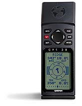
GPS 120 description?
|
The GPS 120 is a new GPS from Garmin that looks like it has GPS 45/40
software but it has a mobile mount (sort of like the GPS 65), a much
larger display, no batteries, and it includes an external antenna.
It looks like it was intended to be permanently mounted in the cockpit of
a boat. The only differences I can see is that the GPS 120 has a Man Over
Board button and an anchor alarm option in the menu.
The GPS 120 sells for about $400 US discounted.
3.00
FIRMWARE (GPS 45/40 INTERNAL SOFTWARE):
---------------------------------------
-90 knot speed limit?
There is a firmware speed limit of 90 Knots (Nautical miles/hour), 104
statute MPH, and 167 km/h. Most of the fields are replaced with dashes or
underlines above the speed limit except for the compass and clock. There is
no doubt that this is a firmware (software) imposed limit. Contrary to many
reports on the internet, the limit is NOT 99 MPH and it is NOT 99 knots!
Almost all other civilian GPS receivers have a maximum speed limit of about
1000 knots and a maximum altitude (of ~50000-65000 ft) to discourage
their use on intercontinental ballistic missiles.
This 90 knot speed limit has created a lot of debate in the GPS newsgroup
primarily because it is not well documented and is arbitrary. Recent reports
indicate that it is now mentioned very briefly deep inside newer versions of
the GPS 40 manual. Obviously every potential customer does not take the time
to read the manual before deciding to purchase the unit. People should
should be warned about the limitation since it is not expected and since most
(if not all) other manufacturers' units do not have this constraint.
This was apparently done to prevent these models from competing with the
aviation models that are priced at several hundred dollars more. This is
a common marketing technique called "market positioning" or "price
positioning". An alternative way to look at it is that aviation unit
purchases help to subsidize the costs of the GPS 45/40/38 models! Garmin's
defense is that this was done to reduce their liability by preventing their
use in aircraft. The other GPS manufacturers don't seem so concerned.
|
There is an aviation model called the Garmin GPS 90 that looks like the GPS
45 except that it has different firmware, a black case, and a couple of
buttons are relabeled. Internally it may have better shielding and more
battery backed up memory. Of course it does not have the 90 knot speed limit
and it has some other software features for aviation use such as a database of
public airports and navigation aids. See the Garmin GPS 90 section elsewhere
in this FAQ.
Because of the speed limit, some people have bought other manufacturers' GPS
units instead. Hopefully this speed limit will be removed in a future
firmware version.
One problem for Garmin might be that if they were to eliminate the 90 knot
limit, how would they handle upgrades for existing customers? Some existing
customers would scream about the $150 price for a firmware upgrade.
Thanks to John M. Lewis (70544.73@compuserve.com) for his well documented
test with a laptop computer in a plane. His report is included below. The
reports of 100 knot or 100 MPH limits were in error!
|
Here is a report of the details by John Lewis:
I took a GPS 45 into an aircraft, it worked OK up to and below 90.0 KTS.
Above 90.0 nautical miles per hour it beeped with "Poor GPS Coverage" and
did not display the track, speed, position, or altitude. The time and
the "compass card" did display. The track map did not indicate the >90Kts
points, nor did the track data download. Upon decreasing speed to 90.0 Kts,
even if only for a second, the full display reappeared, with accurate
position information. During the speed blackout, the sat status page
indicated 8 satellites with nearly full signal strength bars.
The GPS 45 was attached to an HP100LX palmtop for data recording. The
following is an excerpt edited to pertinent RMC sentences:
Garmin GPS 45 V2.32 NMEA V2 RMC sentences
ID, UTC-GPS, LAT , LON , KNOTS,Track, Date
$GPRMC,231109,A,3030.183,N,08819.149,W,087.2,284.8,140595,,*0E
$GPRMC,231111,A,3030.203,N,08819.206,W,086.2,293.9,140595,,*02
$GPRMC,231113,A,3030.229,N,08819.257,W,089.3,300.4,140595,,*04
$GPRMC,231115,V,,,,,,,140595,,*38
$GPRMC,231117,V,,,,,,,140595,,*3A
.
.
$GPRMC,231539,V,,,,,,,140595,,*32
$GPRMC,231541,V,,,,,,,140595,,*3D
$GPRMC,231543,A,3032.451,N,08824.848,W,090.0,097.0,140595,,*06
$GPRMC,231545,V,,,,,,,140595,,*39
$GPRMC,231547,V,,,,,,,140595,,*3B
.
.
$GPRMC,231643,V,,,,,,,140595,,*3C
$GPRMC,231645,V,,,,,,,140595,,*3A
$GPRMC,231648,A,3032.932,N,08824.232,W,086.7,277.8,140595,,*05
$GPRMC,231650,A,3032.915,N,08824.287,W,081.2,256.0,140595,,*0E
Reconfiguring the 45 for display in Statute MPH, the display changed to
dashes at speeds in excess of 104 MPH. When configured for Metric, the
device becomes useless above 167 K/H.
The ability to instantly relock and display correct data upon reducing
speed to 90.0 Kts, as well as the ability to display correct heading via
the compass card indicates a software induced blanking, not a hardware
limitation. There may exist a hardware limitation at speeds in excess
of 110 Kts, this test flight did not exceed 110 Kts IAS.
John M Lewis <70544.73@compuserve.com>
-GPS 45/40 firmware versions:
These versions do not apply to any other Garmin products except the 40 & 45.
The firmware is believed to be identical between the 2 products except that
different model numbers are displayed on power up ("45" vs. "40").
Here are some versions and their differences that have been mentioned in the
newsgroup. Most other differences are not known outside of Garmin.
V2.02 4/94 Early release of GPS 45
...
V2.20 1994
...
V2.24 1994
...
V2.31
V2.32 Shipped for many months
V2.40 5/95 New feature: Fuel Gauge gone when connected to external power
V2.41 6/95 Some units have simulator random power down problem (minor)++
V2.42 7/95 Simulator random power down problem partially fixed
V2.43 9/95 Simulator random power down problem fully fixed
[V2.43 is still the current version 4/1996]
The above dates are approximate within about 1 month.
++Simulator mode is a mode which simulates satellite signal acquisition,
presumably when you are not outside and want to practice with the unit.
You can still program the unit indoors (or wherever you are that you can't
lock onto the satellites) using "normal mode" instead, however in normal
mode the unit will automatically shut down after 15 minutes of not finding
enough satellites (to conserve the batteries).
If you want to update your firmware, you can have the unit serviced at Garmin's
$149 flat rate fee for repairs. It is not a trivial operation. See the
section "Internal electrical hardware" for the details of what is required for
the EPROM replacement.
I have seen the simulator bug in V2.41 of the software. Some reports
indicate that it does not affect all units with V2.41 firmware. If a unit
has the bug, when you are in simulator mode after an apparently random amount
of time (sometimes immediately), the unit turns itself off. You simply turn
it back on or use normal mode and turn it back on every 15 minutes. This is
not a serious problem.
I have not heard of any serious bugs in past versions so it is very likely
not worth upgrading.
It is fortunate for us that Garmin is continually upgrading their firmware.
Many companies don't.
-What are the undocumented modes for the GPS 45/40/38?
Globe spin rate and direction:
Go to the map display. Then press the OFF button for 1-2 seconds. The
globe will still be on the screen and you can change the speed with the
up/down buttons and the direction of rotation with the right/left buttons.
Press any other button to return to normal mode.
Test screen:
Hold down ENTER while pressing on the POWER button.
Invokes button test screen and displays labeled:
SNR Signal to Noise Ratio?
DRIFT of FREQ below
FREQ apparently this is a 16 MHz internal clock
TEMP degrees Celsius
BATTERY voltage in hundredths of Volts
EXTERNAL external power connector voltage in hundredths of Volts |
TIME Universal Coordinated Time without local offset
Press LEFT or RIGHT arrows to adjust contrast.
Press ENTER 2 times to get an all black screen, press ENTER again for cool
exploding rectangles on the display. Press ENTER again to exit this mode.
Hold down OFF button to exit test screen.
Also turns beep on if you had it off!
Full reset and memory clear:
Hold down MARK while pressing on the POWER button (CLEARS MEMORY!!!).
DO NOT TRY THIS UNLESS YOU ARE WILLING TO LOSE ALL SAVED INFO!!!!!!!!!!
Waypoints, Track, Routes and more will all be gone. I would not do this
unless my GPS unit was having serious problems (and then only as a last
resort attempt to fix it before sending it in for repair)! It returns
all settings to initial factory defaults.
Diagnostics mode:
To get into this mode, quickly after turning on the power (while the globe
is still spinning), press all 4 arrows one at a time (in any order).
2 or 3 digit numbers are added to many screens. Their meaning is unknown at
this time.
The signal strength bars are initially hollow. They become solid apparently
when some specific data has been downloaded from the satellite.
The number in the bottom right of the satellite screen (usually something
like 1.3 or 4.2), looks like an indication of the geometric degradation of
[precision] (GDOP). It varies with the number and location of satellites
being received, being lowest when a group of satellites scattered widely over
the sky are present, and highest for a cluster of satellites, or when the
received satellites are all in a straight line. It also seems to vary in
step with the "accuracy" number normally displayed in the top right.
Contributed by proach@cais2.cais.com (Peter Roach)
The internal temperature in degrees Fahrenheit is added to the position
screen to the right of the time.
A "DIAG" option is added at the bottom of the menu screen. The following
is displayed on the DIAG screen:
Battery voltage in hundredths of volts.
Elapsed time (can be zeroed by pressing ENTER).
Screen can be paused by pressing MARK.
Looks like there is a lot of internal software debugging info.
GPS 40 mode [may only work with older firmware versions]:
I just found an interesting feature of my GPS45 (v2.32). Pressing the
center of the thumbwheel switch (engaging all four) upon powerup
results in the welcome screen changing to "Welcome to the Garmin GPS
40", with the same software version mentioned as in the 45
announcement. [Editor was not able to duplicate w/ V2.41 firmware]
Michael J. Klein (mjk@shore.net)
-Why is internal temperature available?
In some electronic circuits, it is useful to measure the internal temperature
so that it can be used to compensate for changes in components
over temperature. As the unit warms up, this internal temperature will
generally be warmer than the ambient (surrounding) temperature. The internal
temperature measurement is not intended for use as a thermometer to measure
the air temperature (although it would probably work well immediately after
the unit is turned on before it warms up).
I would speculate that the temperature is used to monitor the drift of the
16 MHz clock since apparently the frequency drift info is displayed on one of
the screens above.
There are two different modes on the GPS 45/40/38 that allow you to read the
internal temperature. One is in Fahrenheit, the other is in Celsius. See
the previous "Diagnostics mode" and "Test screen" sections above for details.
4.00
BATTERY/POWER:
--------------
-How is power selected between the internal batteries and the external supply?
This differs between the 40/38 and the 45. The 45 switches completely
to the supply with the highest voltage. The 40/38 does a slower crossover
from one supply to the other as the voltage of one exceeds the voltage
of the other, and will draw part of its operating current from a
current-limited external supply such as a solar panel, even if the
current-limited supply cannot supply the total power needs of the GPS
40/38. The remaining current which the solar panel cannot supply is
supplied by the internal batteries.
Larry James (lwjames@csn.net)
If neither is high enough, the unit will shut off to allow the memory to be
maintained.
-What voltages do the fuel gauge correspond to?
I hooked up a GPS45 to a variable supply in the shop and found the following
in testing the battery monitor display.
DC supplied thru battery compartment [V2.32]
Full reading ~5.65v
3/4 ~5.3v
1/2 ~5.00v
1/4 ~4.6v
Empty ~4.25v low battery alarm, unit turns off
Readings did not exactly repeat and there appeared to be some hysteresis,
hence the tilde. Unit transitioned smoothly between external dc and internal
batteries when external power was cycled (unit did not lose sat lock).
davew@cruzio.com (David Wells)
There are variations between units so the above info may not apply
directly to your unit! For example, my unit shuts off between 3.7 and 4.0 V.
You can easily calibrate your own unit by going into diag mode or the test
screen as explained under the FIRMWARE section and just compare the battery
voltage with the fuel gauge at various battery levels.
It is easy to see what your actual battery life is in hours and minutes by
using the elapsed timer in the "Diag mode" and simply zeroing it when you
change batteries.
-Current consumption of a GPS 45 at different external supply input voltages?
This is from a GPS 45 unit with V2.41 firmware and internal batteries removed:
(There are manufacturing variations between units and this does NOT apply to a
GPS 40/38)
Normal Mode (as opposed to Battery Saver mode)
Simulator Mode uses half as much current
POWER POWER
V in OFF ON
---- --- --
6.25 V 1.0 mA unit turned itself off
7 V 1.1 mA 144-166 mA
8 V 1.3 mA 120-138 mA
10 V 1.8 mA 80-100 mA GPS 45 only, GPS 40/38 might be damaged!
12 V 2.3 mA 68-84 mA GPS 45 only, GPS 40/38 might be damaged!
14 V 2.8 mA 62-78 mA GPS 45 only, GPS 40/38 might be damaged!
16 V 3.3 mA 62-76 mA GPS 45 only, GPS 40/38 might be damaged!
24 V 5.2 mA 64-80 mA GPS 45 only, GPS 40/38 might be damaged!
32 V 7.1 mA 64-80 mA GPS 45 only, GPS 40/38 might be damaged!
>From this data, I conclude that you do not want your GPS 45 external supply
to drop down below about 7 Volts. Also, there is no advantage to a supply
with more than about 14 Volts as the extra voltage will just be converted to
heat.
Also (on the GPS 45 at least), there is a big difference between the
battery input and the external power input circuitry.
-How does BatterySave mode work?
According to Garmin's Tech Support Department- These are a couple of the
things the saver does:
1. Stops the unit from trying to re-lock if it loses the birds.
2. Cycles the receiver off and on periodically if you are motionless. (update
time)
Ralph Fowler (rwf@mindspring.com)
However, most people feel that the BatterySave mode offers only a modest
battery life improvement in general use. If you have a strong signal, it
probably does not hurt to leave it in Battery Saver mode. If you
change modes, then the unit loses all satellites and must reacquire them
(although it happens quickly). Also, as is mentioned in the manual, when you
have trouble getting the receiver to lock on the satellites, if you turn the
unit off and then on again it often performs much better.
[Lane A. Holdcroft]
The RF circuitry draws considerable power. In normal mode it is on
continuously. In battery saver mode, after a lock is established and
the necessary data downloaded from the required number of satellites,
the RF circuitry is turned off for short periods, then back on. If the
user's velocity vector is constant during the off period, then when it
comes back on, the satellite signals will be right where the receiver
expects them to be (in time). When the receiver verifies that, it can
go back to sleep again for another short period, saving the batteries.
If the signals are not where expected, if the velocity change is small,
the receiver can quickly find them by searching either side of the
expected time delay. Obviously no change in velocity can be detected
while the RF circuitry is off.
|
The conclusion is: If you are going at a nearly steady velocity under
a clear sky, use battery saver mode. If you are under trees with
marginal signals, or want the fastest possible response to velocity and
direction change, use normal mode.
|
Larry James (lwjames@csn.net)
|
Here is another person's explanation:
The battery saver mode cycles the receiver portion of the GPS on for one
second and off for two (then repeats) to conserve power. The CPU portion of
the GPS is on continuously and interpolates speed/position during the off
cycle. If the GPS has a hard time keeping up with speed/heading changes
(i.e. a "high dynamics" situation) then Battery Save will automatically be
overriden in favor of Normal mode operation. It will revert back to Battery
Save operation (again automatically) once speed/heading readings stabilize.
Battery Save mode will not affect the units ability to lock onto satellites
or its ability to re-lock if it loses satellites.
-Rechargable Batteries?
Renewals:
Rayovac Renewal (tm) rechargeable alkaline batteries work very well in the
GPS 45/40/38 units. They are only rated for about 25 recharges (compared
with approximately 300-1000 recharges for NiCd batteries) but have a longer
life per charge and a slower self discharge rate. Actually, the capacity
decreases about 2% per full discharge/ recharge cycle. They also have about
20% less capacity than normal alkaline batteries. Also the fuel gauge reads
more accurately than with NiCd's. The chargers are about $16 US and the 4 AA
batteries cost about $7 US. Unlike NiCd batteries, alkaline batteries will
last much longer if you charge them often. They are available at large
discount stores such as Walmart, K-mart, & Target in the US.
|
NiCd:
Nickel Cadmium batteries are much cheaper long term than standard alkaline
batteries or even Renewals if you use your unit a real lot. Unfortunately
the battery life is about 5 hours per charge instead of 8 hours for Renewals
or 10 hours for standard alkaline batteries. Unfortunately, the fuel gauge
gives a less accurate state of charge for NiCd batteries because they have a
more constant voltage over their discharge cycle instead of the gradually
decreasing voltage of alkaline. You probably should carry a spare set of
NiCd batteries with you because the fuel guage can drop off very quickly.
I believe that Renewal rechargeable alkaline batteries are a better choice
unless you use your GPS unit very, very often (like myself) and don't want
the expense of replacing your renewal batteries about every 25 charges. I
have used both types of batteries very successfully.
|
-Other battery/external power options?
Of course an optional cord could be used if you have some other DC
power available at the appropriate voltage such as in a car or boat.
Do not forget the 1/4 A fuse!
Some people have also hooked an optional power cord to an external battery
pack that could supply power for days of use. Select your battery pack
voltage carefully! Usually, you do not want most types of batteries to be
discharged below 0.9 V /cell. See a previous section for info on current
consumption at different voltages (for the GPS 45 only). Again, do not
forget the 1/4 A fuse.
For a GPS 40/38 (which has an input voltage of 5-8 V), 5 D-cell alkaline
batteries would work out well (5 x 1.5V = 7.5V). For a GPS 40 with NiCd's, 5
or 6 cells should work. (6 cells would be too high a voltage with other
types of batteries).
-How long is memory conserved without batteries?
I am told that older versions of the 40/45 used a capacitive circuit to
maintain memory while the batteries were changed. As a rule of thumb,
the batteries should not be left out for more than one hour. While in
the field, if the batteries go kaput leave them in the unit. There's
still more than enough juice to maintain the memory until fresh
batteries can be installed.
From the Owner's Manual and Reference, GPS45 Personal Navigator,
Software Version 2.20 or above, 1994, Garmin International,
part number 190-00070-00 Rev. B, page 47,
"Never store your GPS45 without batteries. A built in capacitor will
save almanac and waypoint data while you are changing batteries, but
will only save data for a period of time (a few hours). If you are
storing the unit for the season, put in a fresh set of alkaline
batteries to help prevent the loss of stored data."
DUDLEY2@QUCDN.QueensU.CA
Newer versions (since about mid/late 1995), have an internal rechargeable
lithium battery than maintains the memory when batteries are temporarily
removed. These batteries should last the life of the unit. I believe the
GPS 90 has always had the lithium battery.
-Does the serial I/O consume much more power when it is enabled?
I have measured [the current consumption] with the 45, 50, and 75 and could
see no change measuring down to +/- 1mA. So if it does it is negligible.
Tom Miller (tmiller@umabnet.ab.umd.edu)
I tested the GPS 40 and it too does the same.
davew@cruzio.com
5.00
SERIAL/POWER INTERFACE:
-----------------------
-External serial/power connector alternatives?
Garmin uses a non-standard 4 pin (for GPS 45) round connector (a center pin
is added for the GPS 40/38). I personally recommend buying the cable with the
correct connector from Garmin. Garmin sells a data/power cable for the GPS
45 with the unusual connector and 4 wires for about $30 list. However, some
dealers sell it for much less.
One person reported that a Amphenol connector type T3109-001 will work if
you modify it slightly. I can't find it in the Amphenol catalog. Perhaps
it is only a partial part number. Reportedly it costs around $15!
I personally feel that building your own cable is risky because of the
possibility of mis-indexing the connector which could damage the unit. Also,
there is a risk of intermittent operation due to the mismatch between the pin
and socket size if you do not replace the sockets. I have experienced this.
Some people have substituted a 5 or 8 socket DIN connector for the GPS 40/38 or
a 4 or 7 socket DIN connector for the GPS 45. There are several socket
arrangements for the DIN connectors (even with the same number of sockets!).
You should plug any unused holes (epoxy works) and if you are using the DIN
sockets (not as reliable), you should bend the contacts in to improve the
reliability of the contact with the smaller pins of the GPS 45/40. You also
should wrap the connector with tape and/or heat shrink tubing to bring it out
to the correct diameter. If you do not do a good job on this last step, you
risk damaging your unit due to mis-indexing the connector.
Here is a much better design for a home built cable using Radio Shack parts
that addresses the contact problems above:
The connector for the Garmin GPS 45/40 has been the subject of a number
of inquiries since I last posted my description of how to make one. It is
easy and inexpensive. Here are instructions:
1. Remove sockets from RS-274-001 4-pin mike connector and drill out holes
(1/8"). Drill 5/64" hole for center post (GPS 40). Wrap with (2 turns)
tape (for snugger fit), and cut out tape at key. [heat shrink works well
too]
2. Solder (or crimp) D-Sub socket-pins [RS-276-1538] on cable wires. Put |
plastic (heat-shrink works) tubing on socket-pins and insert them in
connector holes. Fix them in place temporarily with pieces of plastic
tubing pushed in from ends so as to press socket-pins outward (bolt-
circle of GPS pins is larger than that of connector holes).
3. Insert connector into GPS body and push socket-pins down onto GPS pins.
Apply epoxy resin (ca. 3 drops) to inner ends of socket- pins (too much
could run too far down and ooze out end - the tubing that was pushed into
the holes helps prevent this).
4. After epoxy is set, tighten cable clamp to cable, wire cable to
computer/power interfaces, and enjoy.
Rane L. Curl N8REG
ranecurl@engin.umich.edu
Larry Berg of Purple Computing (purple@cdsnet.net) has molded a bunch of
Garmin 45/40/38 connectors. You may want to enlarge the holes slightly.
It is nice of him to help out.
|
There are at least several optional power cables available from Garmin. They
are serial data only, power only, and both. You must supply the appropriate
connectors for the computer end of the cable that has both power and data.
There is even a Garmin to Garmin transfer cable so that you can upload the
stored data from one unit to another. See the accessories list elsewhere in
this FAQ.
See the next section for the pin out.
-How do I interface the GPS 45/40/38 to an IBM-PC compatible computer?
Garmin DB-25 DE-9
Function color* socket socket
-------- ------ ----- ----
data in white 2 3
data out brown 3 2
ground black 7 5
power in red N/A N/A (for ext. power only,
do not forget to add a 1/4 Amp fuse!)
*Garmin 45 manual, Appendix F
I strongly recommend using Garmin's wire colors (as also stated in the
manual) to minimize confusion.
Or for those that like diagrams:
....................25-pin...-or-....9-pin
.....................female...........female
brown�---------------�o3---------------o2
white�---------------�o2---------------o3
black----------+------o7---------------o5
...............|
red +FUSE+.....|
.........|.....|
.........+.....-
.........External
..........Power
Diagram by Tom Clark
[1/4 Amp fuse added by FAQ editor]
If you don't have your manual handy, you can use the following info.
End of cable view: slot clockwise power (red), data out (brown),
ground (black) and data in (white). So the back of the GPS unit is male and
the opposite would be true. That is, from the slot clockwise: data in,
ground, data out, and power. [original contributor unknown]
Unfortunately, to connect to an IBM-PC compatible, you will need one of
two different connector types. The old serial standard (which was also
used on the original IBM-PC) was a DB-25 type connector. Newer computers
may use a DB-25 but most often use a DE-9 connector. You need a female DB-25
or female DE-9 connector to plug into your PC. To find out which,
count the number of pins on the serial port you plan to use (on the back of
your computer). It should be either 9 or 25 pins (not sockets) indicating
which of the 2 types of connectors above you need. Alternatively, you could
use a 9/25 pin adapter to convert between the connector types.
The NMEA 183 hardware standard is NOT RS-232 but is more like RS-422
(simplistically a differential form of RS-232) and will usually work when
connected to RS-232 devices such as a serial port on a PC.
|
Apparently the NMEA 183 spec is now 0V and +5V, but at one time it was
was +/-15V. Protection should be included in newer instruments to
prevent damage by the over voltage. I have not yet seen a copy of the NMEA
183 spec to verify this.
Apparently the (0V to 5 V) GPS 45/40/38 do have some protection for the
IBM-PC compatible +12V and -12V RS-232 levels since most people are
connecting them directly and have not experienced problems.
You can directly connect (using only 3 wires and no handshaking on the PC)
the GPS 45/40/38 to a PC. It does work well for almost everybody but Garmin
will not guarantee it in case there are problems in peculiar circumstances.
The handshaking lines for the PC should not be required for Garmin or NMEA
183 specific software. Some terminal programs could require handshaking
lines tied back on the PC side of the cable.
-How do I interface the GPS 45/40/38 to a Macintosh?
(Files are available in FAQ section "GPS ftp/www sites")
1) In the MacGPS45 program documentation, there is a proven cable design
that is highly recommended for use between the Macintosh and the GPS 45/40/38.
2) There is a good universal NMEA/RS-232 interface design for all types of
computers. You can download the following file from Peter's ftp site:
NMEA_INTERFACE.TXT by Lorne Dudley (dudley2@qucdn.QueensU.CA)
shows a circuit to interface a Garmin GPS50 to a PC or Mac serial port.
It is probably not needed with most PCs, but may provide a more "correct"
interface. It should work with most GPS receivers having NMEA inputs and
outputs.
3) Macintosh software is listed below under APPLICATION SOFTWARE.
6.00
APPLICATION SOFTWARE:
---------------------
-What Macintosh software is available for Garmin GPS units?
MacAPRS - Amateur Packet Reporting System (shareware):
There is also a PC version. This is mapping software written by Radio
Amateurs that also supports GPS and live tracking.
|
There are 3 different versions of MacGPS available. Be sure you get
the correct one for your use:
1: MacGPS45 by John Waers. Source code and application available free at
ftp://ftp.csn.net/Unimac/
ftp://sundae.triumf.ca/pub/peter/index.html
This source code is useful to understand the GRMN/GRMN protocol, but
this should NOT be used for an actual application or as unquestioned
source code for porting to another platform as it has many incorrect-
calculation bugs. It was an unfinished work-in-process which John
donated to the public domain when he moved on to other things. It
doesn't crash, it appears to work, but it gives close but wrong answers
in many cases.
2: MacGPS by James Associates. Application available free from
ftp://mirror.aol.com/pub/info-mac/sci/
latest file starts with "larrys-mac-gps-"...
or any other info-mac mirror site, use the one nearest you.
This used John's code as a starting point (with his blessing), but the
bugs are fixed, the code is faster, the data transferred is correct,
new features have been added, and it works on everything from a Mac Plus
to the latest PowerPC (native code). If you want a free program to
actually use with your GPS 38/40/45/75/90, this is the one to get.
If you are using an earlier version, be sure to upgrade to this latest
version.
3: MacGPS Pro by James Associates. Commercial application.
This has the complete MacGPS functionality, plus graphical plotting of
Waypoints, Routes and Tracks, Waypoint File generation from background
maps, and many other features. [It is very inexpensive]
If you like MacGPS, you will love MacGPS Pro. It has all of the
features of MacGPS, plus many more that our users have been asking for,
including:
* The current GPS data can be spoken by the Macintosh voice
synthesizer for safe use while driving, or for use by the blind.
* A zooming, scrolling moving-map type of display showing waypoints
and routes, plus tracks, current position, and current velocity vector
(speed and direction). Here are the options available on the map menu:
Zoom In
Zoom Out
Fit In Window
Keep Current Position Visible
Keep Current Position Centered
Invert
Show Velocity Vector
Show Route Distances
Wide Track Lines
Show Track Speeds
Show Track Time Stamps
Show Waypoint Names
Show Waypoint Comments
Show Lat-Lon Grid Lines
* A scanned or vector map can be calibrated and used as a background.
* Waypoints, Routes, and Track-Log maps for the GPS receiver screen
may be generated by simply clicking the mouse on the background map.
* Averaging of Real-Time output to obtain more accurate readings.
* Almanac Files showing actual GPS satellite orbital parameters.
* Set your Macintosh clock from the accurate GPS time.
* Display or Upload Real-time (NMEA) files as Track-Log files.
* Choosing a National Grid position format chooses the appropriate
datum.
* Can show Maidenhead grid square location (used by Ham Radio
operators).
* Works in the background as well as in the foreground.
MacGPS Pro sells for [about $30]. People can order it the same way they order
GPS hardware from us (email, phone, fax, snail mail, etc.). They normally
deliver it by email within 2 hours after they get an order, but they can
supply it on disk if someone prefers. It is not shareware, but a regular
commercial product.
Larry James
James Associates
lwjames@csn.net
-What MS-DOS/Windows software is available specifically for Garmin GPS units?
There are 2 general ways that software can communicate with the Garmin GPS
units:
1) Use Garmin proprietary format that allows you to upload and download
waypoints, track info, and routes.
2) Use one of the NMEA 183 software protocols that handles communication
between most NMEA 183 instruments such as autopilots, lorans, compasses,
etc.
Garmin also has some additional unique NMEA 183 style commands which
are useful.
Here is a list of mostly Garmin specific programs:
Garmin's official software kit:
Garmin PCX5 software includes cable with DE-9 connector*
(price lowered to $99 from $150. Who says Garmin doesn't listen!)
|
MS-DOS based.
Reports are that it is a pretty good program.
* I am not sure of the exact wiring of their cable. Are any of the
handshake lines connected? Is this the same cable they sell as an option?
Here is some more info from a contributor:
|
The Garmin PC Software Kit (PCX5) comes with a dedicated GPS - RS232
connector cable, 1diskette and a `30 page manual.
|
The PCX5 software can be used to:
* download route waypoint, proximity waypoint, almanac and track data
* convert route, waypoint and track files to DXF format (CAD)
* display digital map in real time
* graphically plot data files on screen (with zoom, panning, distance
calculation)
* print plot files to printer
* edit and upload routes, waypoints, proximity waypoints and track
data back to GPS
* upload almanac data
* create satellite visibility charts (for route planning)
|
Garmin recommended system to use the PCX5 software on:
* 386 or better
* 2MB RAM
* EMS (to store plot files)
* HD
* VGA
* math coprocessor
* Microsoft compatible mouse
|
I decided to buy the original Garmin software, since I was unaware of
other products at that time. But I don't regret my decision, the PCX5
software is easy to install and works smooth.
|
haehlen@ibm.net (Andi Haehlen)
|
----------------------------------------------------------------------
Fortunately some people have generously written other programs for our
benefit:
GARDOWN6 and GARDOWN7 by M.J. Montgomery (freeware):
Simple but effective MS-DOS programs that download and upload Waypoints,
Track data, and Route data. Because of their simplicity, they are easier to
troubleshoot any serial/cable interface problems. These programs generally
work great with the following caveats:
There is an error in the documentation for the syntax of uploading a file in
GARDOWN7. There should NOT be a space between the "u" and the filename.
The download garmin time "c" option locks up my computers in MS-DOS and causes
a General Protection Fault from Windows for both GARDOWN6 and GARDOWN7.
I personally like GARDOWN6 better for several reasons:
GARDOWN6 inserts a break line between separate tracks (unlike GARDOWN7),
so that when I load track data into a spreadsheet for plotting, it doesn't
connect the trackpoints from different trips (desirable).
I also like the simple help page of GARDOWN6 better.
I received a response from the author indicating that he does plan to release
a new version of the software in a few months but has just been busy with
other work.
|
GARMIN by Peter Aigner (shareware, $30):
A Windows program written in Visual BASIC to upload and download waypoints,
track info, and routes. Since Version A.01.06 it has a several month trial
period. You need to send mail to the author of the program to get a pass
code to enable it for the free trial period until you support it. It
downloads some interesting info such as such as the current satellite
locations.
|
GARMAP.ZIP (from mholdern@sctyhq1.telecom.com.au)
provides an interface between Mapinfo Desktop Mapping Software and a Garmin
GPS receiver, using the proprietary Garmin/Garmin protocol.
Do not forget you have to set your GPS 45/40/38 "I/O SETUP" to
"GRMN/GRMN HOST" or the above programs will not work in Garmin mode.
GMN_DXF1.ZIP (from DNelson@lanl.gov)
converts the data downloaded by GARDOWN into a .dxf file for
import into AutoCad or other drawing programs that read this format.
WINGPS by Jos Verbeek (freeware):
A Windows program written in Visual BASIC that talks NMEA 0183 but also has
some Garmin options. It uses the Garmin data files generated by the utility
GARMIN by Peter Aigner.
-What MS-DOS/Win software is available that communicates using NMEA 183 format?
JNAV82.ZIP by Joel C. Koch (shareware $50):
A MS-DOS program that displays and logs NMEA 0183 data.
GPSNMEA by Dr.W.Pieper (Public Domain): |
A MS-DOS program that displays and logs NMEA 0183 data.
APRS - Amateur Packet Reporting System (shareware $25+):
There is also a Macintosh version (MacAPRS). This is mapping software
written by Radio Amateurs that also supports GPS and live tracking.
|
You could use almost any terminal program and just log the MMEA 183 data of
course. Kermit, Procomm and the MS-Windows Terminal are a few of the most
common terminal emulator programs for PC's.
GARMIN65.NMEA Prepared by Peter Bennett (bennett@triumf.ca)
An annotated listing of NMEA 183 sentences (including Garmin unique sentences)
sent by a Garmin GPS 65. The GPS 45/40/38's implementation of NMEA 183 is very
similar.
Manning Navcomp offers RASTRAC, a WINDOWS/NT/'95/ system that supports
popular GPS hardware and moving maps starting at $195. The ADV and MX
version supports PCMCIA cards, multimedia advisories and GIF/JPEG/etc. A
free version of the software is available for download at
http://www.navcomp.com/navcomp/.
dnichjr@airmail.net (del nichols)
|
-Other GPS Software?
Here is a bunch of info about software from one particular company. I have
never seen any of their products but I have heard some positive reports and
their prices are generally very low.
FOR GARMIN MODE ONLY (GPSXFER):
GPSXFER is utility which can Download Track logs, Download Waypoints, Upload
Waypoints and Combine Files for assembly of map or WayPoint logging.
GPSXFER communicates via the serial port to the GPS in use at 9600 bps.
The protocol used supports only Garmin GPS's with the following model
numbers, GPS-40, GPS-50, GPS-45, GPS-65, GPS-75, GPS-85, GPS-90, GPS-95.
GPSXFER allows the GPS to do all the work in the field by collecting track
logs and Waypoints, then once back to a computer those records can be
retrieved from the GPS by using GPSXFER. The file format that GPSXFER
creates can be used with "GPM-PRO" (also available from Cole Enterprises)
mapping software to view trips and create maps.
GPSXFER runs from DOS. This allows all laptop and Palmtop computers to run
it. It supports both Color and Black and White Monitors. The only
requirements are DOS 5.0 or later, and 400K of available RAM. This program
works great on the HP 200 Palmtop.
Price for GPSXFER is $30.00 U.S.
GSPDASH and GPSXFER bought together are $50.00.
NMEA MODE:
The following is a list of S/W products which might be useful for the Garmin
GPS's. All of these products work with the NMEA string coming out of the
GPS, so this is ideal for the GPS engines.
GPSDASH is designed to receive data transmitted by a GPS over a serial port
and use it to derive, Speed, Max Speed (Bar graph and numeric), Altitude,
Max Altitude,Trip and Total Distance, Latitude and Longitude, Heading
(Compass dial and numeric), Number of Satellites used and D.O.P. (Dilution of
Precision).
Other information displayed in GPSDASH but not derived from the GPS is,
Elapsed Time, Current Time, Remaining memory, Log file name , size and
divider rate.
Distances will be retained from exit of program to re-entry of program so
that long time logging can be maintained.
GPS's used should transmit NEMA 0183 ver 2.0, although earlier versions can
be used but will not contain all of the data. Data rates handled are 4800bps
and 9600bps. This program can be run stand alone or as an auxiliary screen
from "GPM-PRO" mapping software also available from Cole Enterprises.
GPSDASH will automatically initialize the GARMIN GPS-10/20/25/30/31/35/36
series of receivers.
GPSDASH runs from DOS. This allows all laptop and Palmtop computers to run
it. It supports both Color and Black and White Monitors. The only
requirements are DOS 5.0 or later, and 400K of available RAM. This program
works great on the HP 200 Palmtop.
Price for GPSDASH is $30.00 U.S.
GPM-PRO is designed to receive data transmitted by a GPS receiver over a
serial port and use it to create real time maps or read in files to view
from past trips. The views can be scaled to any size such that overlays
can be made for placement on any map. Waypoint entry is extensive which
allows the user to create custom overlays for use with the real time
mapping or post viewing. During real time mapping other statistics
transmitted by the GPS are displayed such as , Speed, Max Speed, Altitude,
Max Altitude,Trip and Total Distance, Latitude and Longitude, Heading,
Number of Satellites used and D.O.P. (Dilution of Precision). It is a very
useful GIS tool. Custom data dictionaries are easily constructed by the
user allowing almost unlimited hot key selections.
GPS's used should transmit NEMA 0183 ver 2.0, although earlier versions can
be used but will not contain all of the data. Data rates handled are 4800bps
and 9600bps.
GPM-PRO will export two file formats: DXF and TXT (which is +/-Lat,+/-Lon
six decimal deg) recognized by Select Street Atlas by ProCD. Conversions to
State Plane Coordinates and UTM and on into DXF are available.
GPM-PRO is a very advanced and capable tool, with far to many features to
list here. For more information call and get the details.
GPM-PRO and GPM-SAT will automatically initialize the Garmin
GPS-10/20/25/30/31/35/36 series of receivers.
GPM-PRO runs from DOS. This allows all laptop and Palmtop computers to run
it. It supports both Color and Black and White Monitors. The only
requirements are DOS 5.0 or later, and 400K of available RAM. This program
works great on the HP 200 Palmtop.
GPM-PRO software package includes companion utility programs to manage and
convert the data files collected by GPM-PRO.
GET-WPTS:
Is designed to extract WPT/feature attributes from the *.GPS data files
generated by GPM-PRO. These WPT/Feature Attributes can be put into a comma
delimited file for analysis or manipulation by a spreadsheet type program or
into Location (*.GPM) or Route/Boundary (*.RTE) files used in GPM-PRO as
route, boundary, or location information.
GET-WPTS will also produce a 7 decimal degree (GEO), State Plane Coordinate
(SPC), or Universal Transverse Mercator (UTM) type file and convert each
these files to *.DXF format for easy importing to many of the CADD programs
available.
SORTGPM: Is a designed to to build custom Location (*.GPM) and Route/Boundary
(*.RTE) files utilizing existing *.GPM data files or Location and Route data
extracted from logging sessions.
GPM-PRO is provided with Location files for cities, airports of over
4,000 ft, and FAA VORs (Navigational Sites) in the USA.
Price for GPM-PRO and Utilities is $250.00 U.S.
GPSDASH and GPSXFER can be purchased for $10.00 each if bought at the same
time as GPM-PRO.
A complete GPS Tracker kit is available, including a GPS, Palmtop PC, and
necessary interfacing cables etc. Call for details and quotes on the
Tracker kit and for Custom software/hardware requirements.
GPM-SAT is a satellite viewing program that will operate stand alone or in
conjunction with GPM-PRO. It shows a sky view of satellites available and
over a period of time, history tracks will develop showing the satellite
movement. Signal-Noise bars are shown for the individual satellites. When
used in conjunction with GPM-PRO, will continue the track log being recorded.
Visa/Mastercard Accepted. Or send Check to:
Cole Enterprises
614 Cedar Hill RD NE
Albuquerque NM 87122-1814
Internet 102115.3550@compuserve.com
Sales (505) 856-7402
(505) 856-7446 FAX
[Software Quantity Discounts are available for 2 or more copies.]
GPM-PRO package includes GPM-SAT $250.00
GPM basic pkg includes GPM-SAT 70.00
GPM-SAT alone single copy 30.00
GPM-SAT if bought with either GPSDASH or GPSXFER 10.00
GPSDASH 30.00
GPSXFER 30.00
GPSDASH and GPSXFER together 50.00
GPSDASH if purchased with GPM basic or GPM-PRO 10.00
GPSXFER if purchased with GPM basic or GPM-PRO 10.00
All orders are plus shipping.
-GPS ftp/www sites?
Caution, these links are constantly changing!
Garmin's software is available though their dealers.
Peter Bennett has an excellent ftp site and WWW page which have most of
the freeware/shareware programs above as well as info on NMEA 183 and a
general GPS FAQ:
ftp to "sundae.triumf.ca", cd to /pub/peter
or web address "ftp://sundae.triumf.ca/pub/peter"
Good general GPS info:
http://www.utexas.edu/depts/grg/gcraft/notes/gps/gps.html
|
Intro to GPS Applications - Archive:
http://www.he.net/~jbeadles/gps/index.htm
Introduction to GPS Applications Web Page:
http://galaxy.einet.net/editors/john-beadles/introgps.htm
You can find some basic GPS information links here:
http://www.inmet.com/~pwt
Tim Hogard has Garmin electrical hardware and Garmin's proprietary
protocol information on his Web site:
http://www.abnormal.com/~thogard
|
Albert Nurick has some GPS info:
http://www.tech.net/technotes/gps/
Larry James has inherited the MacGPS_45 software:
ftp://ftp.hawaii.edu/mirrors/info-mac/sci/larrys-mac-gps.hqx
US Coast Guard:
http://www.navcen.uscg.mil/
US Geodetic Survey:
http://www.usgs.gov/
DeLorme Mapping's home page:
http://www.delorme.com/
APRS (Automatic Packet Reporting System) has both a PC version and a
Macintosh version (MacAPRS) that support GPS and mapping.
It is available from:
ftp to "ftp.tapr.org" cd to "/tapr/SIG/aprssig/upload/"
or web address: ftp://ftp.tapr.org/tapr/SIG/aprssig/upload/
|
US Lat/Lon database by city:
http://tiger2.census.gov/places.html
GPS World magazine (the printed trade publication for professional GPS users):
www.advanstar.com/GEO/GPS/
MIT's scatter plots for GPS w/ SA & GLONASS (Russia's version w/o SA):
http://satnav.atc.ll.mit.edu
The very latest version of this FAQ is available on my www and ftp sites
(however I usually send it to Peter Bennett's site very quickly):
http://www.eskimo.com/~klah/index.html (preferred)
or ftp to "ftp.eskimo.com", cd to "/u/k/klah"
or ftp://ftp.eskimo.com/u/k/klah/index.html
-CD-ROM maps with lat/lon?
This section is very preliminary and so far only has US maps!
DeLorme's Map Expert V2.0 (Windows).
Excellent program, but expensive.
Lat/Lon at cursor. Selectable Lat/Lon grid overlay.
$300 discounted
|
DeLorme's "GPS Link" for Map Expert above
Offers real time track data by reading NMEA 183 output.
$200 discounted
|
(The previous 2 programs are available in the "GPS MapKit" for about $500)
DeLorme's Street Atlas USA V3.0 (Windows).
DeLorme's Street Atlas USA V3.0 (Macintosh).
V3.0 added Lat/Lon support, unlike V2.0.
However, the lat/lon at the cursor is not always displayed under all
conditions. Not nearly as powerful as DeLorme's Map Expert but has the
most important stuff. Generally considered pretty good for the price.
800-452-5931
$80 list price, sometimes heavily discounted.
|
Precision Mapping V2.0
Just Softworks Inc. (708) 257-7616
A little clunky but has many features.
Somebody claimed that there is a "lite" version that does NOT support Lat/Lon.
There is a planned GPS interface option, but it is not expected until 1996.
discounted to about $40.
|
Microsoft Automap Streets V4.00
MS-Windows based.
Turn on lat/lon by selecting Tools,Track.
Lat/Lon is displayed for mouse cursor only.
There is an additional software supplement on Microsoft's BBS but it does
NOT speak normal NMEA or Garmin protocol and is useless on Garmin units!
Someone else is working on some interface software. I don't have any
specifics yet.
List price recently dropped to $55
|
7.00
ANTENNAS:
---------
-What is the GPS 40/38 internal antenna?
It is a "patch" antenna design. The same antenna is also used on the optional
remote antennas GA 27 (GPS 40) and GA 26 (GPS 45) except that the remote
antennas are amplified.
-How is the GPS 45 antenna internally constructed?
Thanks to a friend (Mike Petterson) whose GPS 45 antenna case split open, we
were able to examine the antenna construction. It is a quad-helix circular
polarized antenna. It basically looks like a double sided flexible circuit
board rolled into about a 1/2 inch diameter cylinder. It has 4 spiral
elements that look like the stripes on a candy cane. It is definitely a
a passive (non-amplified) antenna. However, it does work very well.
Several people have reported that when the plastic protective antenna case
is removed, it doesn't work as well.
Someone has X-rayed their GPS 45 antenna and scanned the image.
Look at the files grm45ant.gif and grm45ant.inf on Peter Bennett's ftp/www
site as listed elsewhere in the FAQ.
-How well does the internal antenna work inside a car?
You can use a GPS unit on the dash of your car with the normal antenna but
the roof of the cars shields about 1/3 of the satellites. I typically get
4-6 satellites (adequate) on the open road and less when between buildings
or trees. Of course it depends on the slope of your windshield and where
you place your GPS unit.
|
There are some window tintings (which could also be used in a sunroof)
and some electric window defoggers that use a conductive coating
between the layers of glass that block the satellite signals. These
are unusual but they will shield the signals from the antenna.
|
Of course you can get much better reception with an external antenna on
the roof.
-What are the remote antenna options?
GPS 45/40:
There are several basic approaches to external antennas:
1) Obtain an external antenna. If the coax is going to be longer than
several meters, then the antenna should be amplified to overcome the
signal losses in the coax. The GPS 45 and 40 supply 5 V to the coax
connector.
2) Use the existing non-amplified antenna and insert a short piece of
coaxial cable between the connectors. With this approach, you only have
to pay for a coaxial cable extension and perhaps a gender changer and/or
90 degree elbow.
The satellite signals are severely attenuated by coaxial cable at the
civilian GPS frequency of about 1.5 GHz. If the original (non-amplified)
antenna is used, the cable length should usually be kept less than about 3
meters.
Garmin sells a couple of external antennas that work very well. There is a
wide range of mounting options including suction cups, magnetic, flange, and
trunk lid mounts. See the accessories section of the FAQ for details.
Many people have reported that the external antennas work better than the
built in antennas when they are walking through trees. This could be
because your body is not shielding the signal and most external antennas are
amplified. If you are walking, you could mount the external antenna to your
hat or to a pipe coming out of a backpack.
Garmin sells a non-amplified remote antenna for the GPS 45 for about $40.
I have not heard any reports about it yet. It sounds like a good low cost
solution for use with your car or when walking as used above.
-GPS 45 antenna extension cables?
You can buy a SHORT coax extension and mount the antenna on the inside of
your windshield or sunroof.
Radio Shack sells 6 foot coax RG-58/U extensions with suction cup mounts (RS
20-022) or a window edge mount (RS 20-023) for about $15. You will need a 90
degree elbow (RS 278-116a) for the window edge mount and it can be useful for
the suction cup mount too. The window edge mount has worked well for many
people. However there is a risk of antenna theft or possibly the antenna
flopping down or falling off. Also, the coax can get pinched in the window
or alternatively there will be a noisy air leak. You can also just buy a
piece of coax but you will also need a BNC gender changer and a way to mount
it.
|
The 6 ft of RG-58/U (a very lossy coax at these frequencies) drops the signal
strength a little on the display.
Garmin offers a 6 ft antenna extension for the GPS 45 (Garmin 5519). It has
a screw/suction cup mount. It costs about $40.
|
-Can I make my own external antenna?
Yes. There have been several postings that reference the articles below.
A GPS antenna is difficult to design for many reasons:
The signal is very weak.
The frequency is quite high (1.5 GHz).
Antenna tuning is very difficult because of the expensive equipment required.
A hemispherical radiation pattern is desired.
Right hand circular polarization is desired.
In the ham radio magazine "QST" (October 1995) there is a good article
on how to simply construct a "patch" style GPS antenna using easy to
obtain materials. The file "gpspatch.zip" on Peter's ftp site also has
lots of information. It is relatively easy to construct and the
materials are inexpensive! You may want to use an easier to solder
material than aluminum if you don't have copper foil tape or
appropriate solder and a large iron.
Some people have found the signals to be weaker but they all have worked.
Several people reported that it doesn't work as well for satellites near the
horizon. However, it is still the best antenna design I have seen so far for
home construction.
The "Satellite Experimenter's Handbook" (by Martin R. Davidoff,
published by the American Radio Relay League) has a quadrifilar helix
antenna. It could be tough for many people to get the very small coaxial
hardline that is needed. The dimensions are very also critical. This
particular antenna apparently presents a dead short to the +5V supply on the
GPS unit's external coax connection if connected normally. Therefore, the
antenna likely needs to have a small decoupling capacitor in series with the
center wire of the coax to prevent blowing the internal fuse ($150 service
charge!). When my antenna is complete I'll post more.
If the coax is longer than several meters, you will likely need an amplifier
to overcome losses in the feedline. Several people have suggested the Mini
Circuits MAR-6 amplifier which looks like an excellent choice because of its
low voltage, low current, good gain at 1.5 GHz, and its ease in impedance
matching. It also only costs about $2 in quantities.
Apparently, Ma/Com also makes a GPS preamplifier IC ($8) which is
designed for this application (but much harder to obtain).
-What is the loss for different coaxial cables?
Based upon information in the spec sheets for coaxial cable, I think RG-6/U
(75 ohm) coax is the most attractive from a standpoint of loss at 1.5 GHz and
flexibility but it is not 50 ohms. Another poster independently came to the
same conclusion. The loss would not be much of an issue if the run was less
than several meters.
The losses due to a impedance mismatch would likely be less significant than
the attenuation of the cable (at least for longer runs). Even Garmin uses
RG-59/U coax (75 ohm) on one of their external antennas.
loss per 100 feet
RG-__/U Z OD(in.) dB (@1GHz)
SORTED BY IMPEDANCE & LOSS:
218 50 .880 4.5
219 50 .880 4.5
217 50 .555 6
8 52 .415 8.8
212 50 .336 8.8
213 50 .412 8.8
215 50 .412 8.8
214 50 .432 9
223 50 .216 17
55 53 .206 17
58 50 .200 20 (solid center?)
58A 50 .200 23 (stranded center?)
58C 50 .200 23
174 50 .105 >>20
6A 75 .274 11.2 *best tradeoff between size, loss, & impedance?
59 75 .250 14
62 93 .250 9
71 93 .250 9
63 125 .415 6.5
Here is another chart from another source showing the maximum cable lengths.
Note that the cable loss specs are different probably because there are
minor variations in the coax type.
Max cable length for a non-amplified antenna is about 8-9 feet using RG59
and 6 feet using RG58. Other cable types will differ.
Here's a cable loss chart for a Garmin amplified antenna:
CABLE TYPE MAXIMUM LENGTH RATING AT 1GHz
RG211A/228A 217 ft 4.5 db/100'
RG217/224/293/14 126 3.8
RG8/215/216 87 9
RG6/142 71 11
RG59 64 11.5
RG58 40 20
RG88 26 30
-What is the GPS 40 antenna connector?
The Garmin GPS 40's antenna connector is called an MCX connector.
One primary manufacturer of these connectors is:
Huber & Suhner Inc.
One Allen Martin Drive
P.O. Box 400
Essex, VT 05451
One of the representatives (who sent me their 1" catalog of RF
connectors) is:
C.W. Swift & Associates, Inc.
15216 Burbank Blvd, Suite 300
Van Nuys, CA 91411
(818) 989-1133
(818) 989-4784 (Fax)
(800) "MICROWAVE" -> 642-7692
Keith Huie
I talked to C.W. Swift & Associates today and the Garmin GPS 40
antenna connector (MCX) has the part number 16MCX-50-2-5C/133 (this is
the right-angle version [for RG-316 cable]). It costs $5.01 qty. 1 and
they have a minimum order of $50. They will take orders less than $50
but will charge $5 for handling.
Tim Tsai
They also have cable assemblies with an MCX on one end and either
F, BNC, or TNC on the other. Cable can be either RG-179 (75 ohm) or
RG-316 (50 ohm). These cables are small diameter and not real low loss.
I would suggest getting a 1 ft cable assy and then adding on a length of
a much lower loss cable such as Times Microwave LM-240 or even LM-400 to
go the rest of the distance.
Jerry Lucha
|
8.00
MISCELLANEOUS:
--------------
-GPS mounting options?
Garmin sells a very nice swivel clamp bracket for $45 (list). It used to be
included w/ the GPS unit but they lowered the price and removed it and a
cable. There are other companies that make GPS mounts, ham radio mounts, and
cellular phone mounts for less money but they are not as nice as Garmin's.
Velcro (tm) adhesive strips (the generic name is "hook and loop" fasteners)
work out well for use in many locations and are very inexpensive and are
available at Radio Shack and some sewing supply stores.
|
-Waterproofness:
The GPS 45/40 is called "waterproof" but everybody's interpretation of
waterproof is different.
Generally speaking, if it is not tested to a specific industry or military
waterproofness standard (which I believe the GPS 45 & 40 aren't), then the
waterproofness probably is NOT reliable and the unit probably should not be
submerged.
|
A marine electronics design engineer pointed out that it is difficult to
make electronics truly waterproof due to changes in pressure due to
temperature.
It is also filled with nitrogen to prevent the screen from fogging.
More than a few people have reported leaks resulting in fogging in which the
unit was submerged. This was usually due to use in a kayak.
The battery compartment is not waterproof (to allow venting for the batteries)
and it would seem to be a good idea to dry out the compartment and batteries
after exposure to water.
I would NOT submerge the units although they should be able to take
some splashed water. It was recently suggested to me by a dealer
that when the units are held horizontal and splashed water collects on
the keys, it can result in leaks around the keypad. He suggests mounting
the unit at an angle to shed water instead of mounting it horizontally.
|
So far Garmin has been pretty good about supporting their one year
warranty. After that, you are on your own!
If you don't want to take any chances and expect to submerge it, I would buy
a marine radio waterproof plastic bag at well stocked marine supply stores.
They usually have a huge Zip-Lock (tm) type seal which keeps the water out
pretty well.
If you were to open the case, you would break the ultrasonically welded seal
and it would leak water. It is NOT resealable.
It has been suggested that you should grease the GPS 45 antenna connector
before exposing it to salt water to help prevent corrosion. I have heard
reports of significant corrosion after the BNC connector was splashed with
salt water.
Some people have suggested that that the GPS 40 is a little more waterproof
and corrosion proof because it doesn't have a BNC connector. This would be
especially true for the GPS 38 since it does not have any external antenna
connector.
|
-Cases?
The case that now comes with the unit is strictly a carrying case and the
unit is not operable with it because it does not have a clear window.
|
West Marine has a blue (formerly yellow) neoprene rubber "floating" padded
carrying case with a somewhat clear plastic window (for use of the buttons
and display) and its name printed on it for $12. The West Marine part# is
253791. It does not keep water away from the GPS unit. It looks like it
was designed for the GPS 40. The GPS 45 is a little tight around the antenna
connector where the antenna hangs off so you have to careful how you swing
the antenna. It is a good investment in my opinion. However, the display
is not as easy to read through the flexible plastic window.
-Garmin 45/40/38 wish list?
Here is a list of suggestions for Garmin that people have suggested and
which I think would have broad appeal in my order of priority:
Remove the 90 knot speed limit.
Add distance traveled function (not straight line distance between 2
points). Perhaps select end points by waypoints or on track log.
This data is already in the track log.
[this was included in the new GPS 38]
Add a display mode in which the velocity and heading in degrees are in
HUGE numbers for easier viewing from a distance.
Add selectable stationary position averaging feature for more accuracy
(such as offered by Trimble).
Add selectable longer averaging time for velocity. Currently it seems about
5 seconds? Velocity is currently of little value for sailboats due to SA.
Remove the limitation of only showing the 9 closest waypoints on the
track log map. This is very annoying and seems totally unnecessary!
It would also be nice to have more than one page of "closest waypoints".
Allow editing for renaming of existing waypoints and creation of new
waypoints. Usually the new name is similar to an existing name and it is
frustrating to have to start from scratch instead of starting with the
existing names.
Use flash ROM so the unit's software could be upgraded through the serial
port. Unfortunately it would be more expensive.
Add "up and over" feature to automatically handle map interpolation
(such as offered by Trimble).
Adjustable proximity alarms would be a nice feature. If/when SA were
turned off, these could be used as anchor alarms.
Remove the limitation of only showing waypoints within about 100 nautical
miles of the current location on the track log map. This also seems
unnecessary!
-Can I use my GPS unit in a plane?
You must first have the pilot's permission. It is possible that the GPS unit
could interfere with the navigation/communication systems. This does not
usually happen, but it could. This is true for many electronics,
especially if they involve a radio receiver (which is part of a GPS unit).
It is against most airline policies to allow the use of most personal
electronic devices during takeoff and landing (and some extend beyond that).
I have not seen the specific FAA rules so am not sure if they have additional
limitations.
Of course, the GPS 45/40/38 will not work above 90 knots anyway so it would
only be useful on slow planes or gliders.
-Performance in trees?
GPS reception is always difficult in thick trees for all GPS receivers. The
attenuation depends on the density of the canopy, and how much moisture is in
and on the leaves. If the canopy is too dense, you may have to find a
clearing to get a fix.
Several people have reported that the external antennas work better than the
built in antennas when they are walking through trees. This probably is
because your body is not shielding the signal and most external antennas are
amplified. If you are walking, you could mount the external antenna to your
hat or to a pipe coming out of a backpack.
The GPS 45/40/38 does not perform quite as well as a few other units when
surrounded by trees. This is because the GPS 45/40/38 is a single channel
sequencing receiver that sequences between 8 channels instead of having 5-8
continuous channels like some other units. Continuous receivers are able to
track more marginal signals at once. However, they cost more, are larger,
and do not have the battery life of a sequencing receiver such as the GPS
45/40/38.
The portable Trimble products and the Eagle Accunav are the most
often mentioned examples of portable GPS units with parallel receivers.
Trimble products are considered to be of high quality but are expensive
compared to the Garmin 45/40/38 and not as feature rich.
|
The Eagle Accunav (the Lowrance Global Nav is somewhat similar) is
considered by many in the newsgroup the other good buy in inexpensive GPS
units. There is a review on Peter Bennett's ftp/www site listed elsewhere
in the FAQ.
It has some advantages:
It has a parallel receiver unlike the Garmin 45/40/38
It does not have the 90 knot speed limit of the Garmin marine units.
It has a larger graphical display.
It is not expensive for a parallel receiver at about $400 US discounted.
It also has a NMEA serial port.
|
However, there are some disadvantages to the Eagle Accunav:
It only has one mapping datum.
It is somewhat larger than the GPS 45/40/38.
It has a very short battery life using its internal batteries
(but would work fine with an external battery pack).
|
-Internal electrical hardware?
Tom Miller and Tim Hogard bravely took apart their GPS 45/40 units and they
described the circuit board. Check out Tim Hogard's home page as listed in
the ftp/www sites section elsewhere in the FAQ for more information.
Here are some of the most interesting identified parts:
Manuf. Part No # pins Function
INTEL TS80L188EB13 80 CMOS 80188EB cpu
ATMEL AT27LV020 32 3.3V 256k x 8 (2Mbit) EPROM
DALLAS DS1202 8 serial time IC & small NVRAM
MITS M5M5256CVP 28 32K x 8 SRAM
PHILIPS SA626DK 20 FM IF amp,det,limtr,mixer,osc
GARMIN ? custom IC #1
GARMIN ? custom IC #2?
The Intel 80L188EB microcontroller is a derivative of the Intel 8088
microprocessor used in the original IBM-PC.
Contrary to some initial reports, the firmware is not in flash memory. (Flash
memory would be of interest because flash is re-programmable without removing
the part from the board).
The EPROM (which contains the firmware) is a "One Time Programmable" (really
an EPROM without a window) surface mount unsocketed part. It must be replaced
for a firmware upgrade.
The fact that the firmware is in EPROM, explains why it costs so much for a
firmware upgrade (not that an upgrade is necessary). It would require
breaking open the case, desoldering the surface mount EPROM, resoldering the
new one, testing the unit, replacing the case, ultrasonically welding the
case, filling the case with nitrogen and resealing it.
-Why is the firmware not in a socket?
There are several reasons why manufacturers generally are reluctant to use
sockets:
1) Reliability. There is a much less reliable connection with sockets.
2) Cost. Sockets (other than for DIP IC's) are usually expensive.
3) Clearance. Sockets require more space above the circuit board.
The only advantage is that sockets make firmware upgrades and troubleshooting
easier.
-Can I receive GPS signals through my house?
Sometimes you can receive a signal indoors. A metal roof, metal siding, or
metal foil vapor barrier would block most of the signal.
Of course, even if there isn't any metal blocking your signal, other
construction materials such as wood or roofing materials will attenuate the
signal to a lesser degree and entirely block it if there is enough between
your antenna and the satellites.
-For how long will a particular track interval interval collect data?
I just got my new Garmin 45 last Friday and played with it over the
weekend at my deer lease. I kept wondering where I should set the logging
to so I put together the following table. It may help others.
Garmin 40/45/38 Capabilities based on 768 Points
Sample Rate Sec Min Hr Day
1 per sec 768 12.8
1 per 5 sec 3840 64 1.1
1 per 10 sec 7680 128 2.1
1 per 15 sec 11520 192 3.2
1 per 20 sec 15360 256 4.3
1 per 30 sec 23040 384 6.4
1 per 45 sec 34560 576 9.6
1 per min 46080 768 12.8
1 per 1.5 mn 69120 1152 19.2
1 per 2 min 92160 1536 25.6 1.1
1 per 2.5 min 115200 1920 32.0 1.3
1 per 3 min 138240 2304 38.4 1.6
1 per 5 min 230400 3840 64.0 2.7
1 per 10 min 460800 7680 128.0 5.3
1 per 15 min 691200 11520 192.0 8.0
1 per 20 min 921600 15360 256.0 10.7
1 per 30 min 1382400 23040 384.0 16.0
1 per hour 2764800 46080 768.0 32.0
MacBob1240@aol.com (Robert C. White)
9.00
GARMIN PRODUCTS:
----------------
-Garmin GPS models?
WARNING:
There could be some mistakes! List prices change often.
Discounted prices can be variable and they only apply to some dealers in the US.
OUTDOOR/MARINE PRODUCTS
INTRO $US $US
MODEL USE YEAR SPEED LIMIT DISC LIST
----- --- ---- ----------- ----- -----
GPS 38 marine, hiking handheld 1996 90 knots $200 $300
GPS 40 marine, hiking handheld 1994 90 knots $270 $425
GPS 45 marine, hiking handheld 1994 90 knots $295 $495
GPS 50 marine, old, replaced by GPS 75 <1992 90 knots? NA NA
GPS 65 marine mount, works like GPS 75 1992 90 knots $400 $665
GPS 75 marine, hiking handheld 1992? 90 knots $490 $825
GPS 80 military version of GPS 40 1995 ?
GPS 120 marine mount 45 w/ big display 1995 90 knots $400 $750?
GPS100MRN handheld/portable 90 $1850
GBR21 DGPS beacon receiver n/a $500 $799
MAP 205 chartplotter, no GPS n/a $770 $1249
GPSMAP 210 chartplotter, B&W 90 $1000 $1655
GPSMAP 220 chartplotter, color 90 $1650 $2730
Notice that all of Garmin's marine units have an artificially low
speed limit. This speed limit did not start with the Garmin 45 as some have
suggested.
AVIATION PRODUCTS
$US
MODEL USE SPEED LIMIT LIST
GPS 55 aviation (discontinued?) 1992 695?knots?
GPS 90 aviation, similar to GPS 45 1995 999 knots ~$690 $799
GPS 95XL aviation ? ~999 knots? $1495
GPS 100 STD handheld/portable 999 $1795
GPS 100 PRT handheld/portable w/ dbase 999 $2095
GPS 100 AVD handheld/portable w/ mnt rack 999 $2495
GPS 150 panel mount, VFR 999 $2995
GPS 155 panel mount, IFR, n-p approach 999 $4995
GPS 165 DZUS rail mount version of GPS 155 999 $6495
GNC 250 panel mount GPS/COMM 999 $3250
OEM/BOARDS/SENSORS
[These units do not have displays. They are for remote use only.]
$US
MODEL USE SPEED LIMIT LIST
GPS 20 MulitTrac8 sensor board (eval kit), 999 kts $499
$150 in quantity w/o antenna,
$240 in quantity w/antenna
GPS 25 PhaseTrac12 (eval kit),
12channel sensor board (eval kit), 999 kts $599
$225 in quantity w/o antenna,
$315 in quantity w/antenna
[this has a parallel receiver]
GPS 30 Integrated antenna/sensor board 999 $340 $499
(eval kit),
$240 in quantity
GPS 31 Marine mount version of GPS 30 999 $355
GPS 35 12 channel version of GPS 30 999 $599
(eval kit),
$315 in quantity
GIS/SURVEY PRODUCTS
$US
MODEL USE SPEED LIMIT LIST
GPS SRVY II portable w/ datalogging capabl. 999 $2995
-Garmin accessories?
Here is a list of most Garmin accessories:
List prices as of Feb 1995:
[THESE PRICES ARE OLD AND SOME OPTIONS HAVE BEEN DISCONTINUED]
GPS40
part number Item description list price
GA27 Low Profile remote ant w/8ft [RG-174] $ 160.00
cable MCX connector & magnetic&suction mount
010-10061-00 Trunk lip mount GA 26/27 18.95
010-10062-00 Flange mount GA 26/27 18.95
011-00152-00 Suction cup mount GA 26/27 18.95
011-00153-00 Magnetic antenna mount GA 26/27 25.00
320-00048-00 8 ft extension cable GA 27 40.00
4015 GPS 40 carry case 35.00
4040 GPS 40/45 Cross load cable(unit to unit) 50.00
4041 GPS 40/45 PC Interface cable 30.00
4042 GPS40 data cable 25.00
4050 GPS 40 cigarette lighter adapter 50.00
4514 GPS 40/45 PC Software and cable kit 150.00
4518 GPS 40/45 mounting bracket 45.00
GPS 45
GA 26 low profile remote ant w/magnetic&suction
cup with 8 ft cable BNC connector 160.00
320-0049-00 8 ft extension cable for GA 26 40.00
GA 28 low profile remote marine ant w/30 ft
cable and BNC connector 160.00
010-10067-00 GA 28 flange mount kit 22.00
1011 Marine/RV remote ant w/30 ft cable BNC 160.00
1013 30 ft low-loss ant ext cable w/connectors 115.00
1028 Magnetic mount ant with 10 ft cable 160.00
4522 GPS 45 handheld/portable ant 100.00
GPS 45-000 Portable antenna 495.00
GPS 45-100 Portable antenna Marine/RV remote mount 655.00
GPS 45-200 Portable antenna, Magnetic mount antenna 655.00
5519 Remote antenna mount: suction cup/screw
mount w/ 6ft cable BNC 40.00
4040 GPS 40/45 Crossload cable (unit to unit) 50.00
4041 GPS 40/45 PC interface cable 30.00
4514 GPS 40/45 PCX5 Software and cable kit 150.00
4515 GPS 45 carrying case 35.00
4518 GPS 45 mounting bracket 45.00
4520 GPS 45 power/data cable 30.00
4550 GPS 45 cigarette lighter adapter 25.00
Disclaimer: These prices may not be current list check around and
see if deals exist
Sid wa2fxb@ix.netcom.com ( a buyer not a dealer, stockholder and
have no vested interest in Garmin)
-Where can I purchase a unit?
Garmin should be able to locate a local dealer.
New address and phone numbers: |
Garmin International |
1200 East 151 St. |
Olathe, Kansas 66062 |
Toll free: (800) 800-1020
Non Toll free: (913) 397-8200 |
Existing Fax: (913) 599-2103 |
New Fax: (913) 397-8282 |
Many marine supply stores carry the GPS 45, 40, and 38. |
Here are some most often mentioned sources for Garmin products:
Bass Pro Shops 800-227-7776 or 417-863-2499 |
Boater's World 800-826-2628 or 206-575-1920? |
Cabellas 800-237-4444 or 308-234-5555 |
E&B Marine 800-533-5007 or 908-819-7400 |
West Marine 800-538-0775 or 408-728-2700
Larry James of James Associates 303-530-9014
new E-mail address: lwjames@csn.net |
[As well as being a Garmin dealer, Larry is very knowledgeable about
Garmin units and often answers questions in the GPS newsgroup.]
----------------------------------------------------------------------
Repeating:
I am not affiliated with Garmin or any of their retailers.
This document is not in any way endorsed by Garmin International.
I am only a satisfied customer.
Lane A. Holdcroft
klah@eskimo.com
KE7UT